
Topo map OS Landranger 115 Prominence 176 m | OS grid SH586563 Elevation 674 m Mountain range Snowdon Massif | |
 | ||
Listing Marilyn, Hewitt, Nuttall Similar Snowdon, Moel Eilio, Foel Gron, Llechog, Foel‑goch | ||
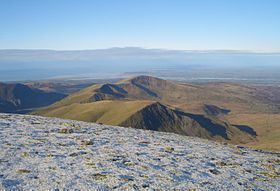
Moel Cynghorion (the Hill of the Councillors) is a mountain in Snowdonia, North Wales. It lies several miles north-west of Snowdon, and forms part of the Moel Eilio Horseshoe walk. The summit is situated on a wide plateau, marked by a pile of stones. The southern slopes are gentle, while the northern aspect is precipitous. The summit has close views of Clogwyn Du'r Arddu and Yr Wyddfa. Views from the summit can extend as far as Holyhead in Anglesey to nearby towns and villages in Gwynedd such as Caernarfon, Llanrug and Llanberis. On a clear day the Wicklow Mountains in Ireland can be seen across the Irish Sea, at a distance of approximately 80 miles away.
Contents
Map of Moel Cynghorion, Caernarfon, UK
Hewitts moel cynghorion
References
Moel Cynghorion Wikipedia(Text) CC BY-SA