
Length 426 km Basin area 23,500 km² | Basin area 23,500 km² | |
 | ||
- location Unorg. Cochrane District | ||
The Missinaibi River is a river in northern Ontario, Canada, which flows northeast from Missinaibi Lake, north of Chapleau, and empties into the Moose River, which drains into James Bay. This river (including Missinaibi Lake and Moose River to James Bay) is 755 kilometres (469 mi) in length. It is one of the longest free-flowing and undeveloped rivers in Ontario.
Contents
- Map of Missinaibi River Algoma Unorganized North Part ON Canada
- History
- Tributaries
- Missinaibi Provincial Park
- References
Map of Missinaibi River, Algoma, Unorganized, North Part, ON, Canada
The river's name means "pictured waters" in the Cree language which is thought to refer to the pictographs found on rock faces along the river.
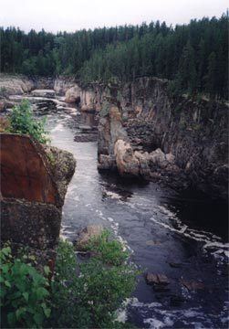
At Thunderhouse Falls, which is actually a chain of relatively small waterfalls connected by violent rapids, the river drops 40 metres, part of its descent from the Canadian Shield to the Hudson Bay Lowlands.
History
In fur trade days the Missinaibi was the main route between James Bay and Lake Superior. The route was: James Bay, Moose Factory, Moose River (Ontario), Missinaibi River, Missinaibi Lake, portage probably via Crooked Lake, Dog Lake, Michipicoten River to Fort Michipicoten on Lake Superior. Trade was contested by the English from the north and the French from the south. In 1774 the Hudson's Bay Company began building posts in the interior. In 1775-76 Edward Jarvis from Henley House went up the Kenogami River, crossed to the Missinaibi and went down to Michicopicten. In 1781 Philip Turnor surveyed the Missinaibi route to Michicopicten.
The three main posts, all at times called Brunswick House or similar were
Today, the river is used for canoeing, fishing and camping. Recreational use is facilitated by an arrangement which allows canoeists to load their boats on a train so they can be returned south, after canoeing the wild stretches of the river. The river is managed as a provincial waterway park and was designated as a Canadian Heritage River in 2004.
Tributaries
Missinaibi Provincial Park
The entire length of the Missinaibi River from Missinaibi Lake to the Moose River is protected and part of the Missinaibi Provincial Park. The park also includes Missinaibi Lake, Brunswick River, Brunswick Lake, Little Missinaibi River, and Little Missinaibi Lake.
Established in 1970 the park is huge and encompasses in total over 991 square kilometres (383 square miles) of wilderness.
While rarely visited by travellers it is well-known amongst canoeing enthusiasts and is one of their "must visit" destinations.
Two main routes are available to paddlers:
1. Missinaibi River Route - stretching for 238 kilometres (144 miles) from the towns of Missinabie to Mattice
2. Mattice to Moosonee Route - This 316 kilometre (190 mile) route takes paddlers to the edge of James Bay and the near arctic.
Other activities at the park include: Hiking, fishing, camping, wildlife viewing and hunting