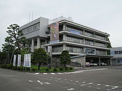
Phone number 025-373-1000 Population 45,408 (1 Jun 2016) | City Niigata Area 100.9 km² Prefecture Niigata | |
 | ||
Address 1235 Shirone, Minami-ku, Niigata-shi, Niigata-ken 950-1292 | ||
Minami-ku (南区, Minami-ku) is one of the eight wards of Niigata City, Niigata Prefecture, in the Hokuriku region of Japan. As of 1 June 2016, the ward had an estimated population of 45,408 and a population density of 450 persons per km². Its total area was 100.91 square kilometres (38.96 sq mi).
Contents
- Map of Minami Ward Niigata Niigata Prefecture Japan
- Geography
- Surrounding municipalities
- History
- Education
- Railways
- Transit bus
- Highways
- Places
- Event
- References
Map of Minami Ward, Niigata, Niigata Prefecture, Japan
Geography
Minami-ku is located in an inland region of north-central Niigata Prefecture. The area is dominated by agriculture, notably rice production and horticulture.
Surrounding municipalities
History
The area of present-day Minami-ku was part of ancient Echigo Province. The modern town of Shirone and village of Ajikata were established on April 1, 1889 within Nakakanbara District with the establishment of the municipalities system. The village of Tsukigata was created on April 1, 1906 by the merger of three hamlets. Shirone was elevated to city status on June 1, 1959. The city of Niigata annexed Shirone, Ajikata and Tsukigata on March 21, 2005. Niigata became a government-designated city on April 1, 2007 and was divided into wards, with the new Minami Ward consisting of the former city of Shirone and former villages of Ajikata and Tsukigata.
Education
Minami-ku has 11 public elementary schools and six public middle schools. There is one public high school operated by the Niigata Prefectural Board of Education.
Railways
Minami-ku is not served by any passenger rail service. A railway line operated by Niigata Kotsu ceased operations in 1999.
