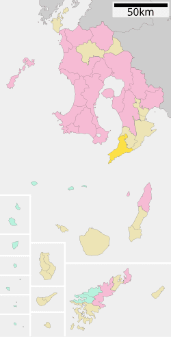
Population 9,897 (Oct 2005) | Area 213.6 km² Local time Monday 6:38 AM | |
 | ||
Time zone Japan Standard Time (UTC+9) Weather 6°C, Wind NE at 3 km/h, 91% Humidity District | ||
Minamiōsumi (南大隅町, Minamiōsumi-chō) is a town located in Kimotsuki District, Kagoshima Prefecture, Japan. The town occupies the southern part of the Ōsumi Peninsula and its name literally means "the southern part of Ōsumi."
Contents
- Map of Minamiosumi Kimotsuki District Kagoshima Prefecture Japan
- Geography
- Neighboring towns
- History
- Town formation
- Town hall
- High Schools
- Junior High schools
- Elementary schools
- Bus
- National roads
- Toll roads
- Famous places
- Events
- Famous natives
- References
Map of Minamiosumi, Kimotsuki District, Kagoshima Prefecture, Japan
The town was formed on March 31, 2005 from the merger of the towns of Nejime and Sata, both from Kimotsuki District.
As of the 2005 national census, the town has a population of 9,897. The total area is 213.59 km².
Geography
Located at 31 degrees north latitude, Minamiōsumi is the southernmost town on the Japanese "mainland" (Japan's four main islands).
Neighboring towns
History
The town name was chosen from among ideas submitted by the public.
Town formation
Town hall
The former Nejime Town Hall now serves as the Minamiōsumi Town Hall. The former Sata Town Hall is now a branch office.
High Schools
Junior High schools
Elementary schools
Bus
Minamiōsumi is served by the Osumi Kotsu Network of buses, operated by the Kagoshima Kotsu Group.
