
Elevation 5,200 m | ||
 | ||
Similar Namcha Barwa, Riyue Mountain, Gyala Peri, Xueshan, Noijin Kangsang | ||
Mila Mountain, or Mira Mountain (Chinese: 米拉山; pinyin: Mǐ lā shān), is a mountain in the Tibet Autonomous Region of China, roughly 150 kilometres (93 mi) by road northeast of Lhasa. The road pass that runs by its peak is one of the highest on China National Highway 318.
Contents
Map of Miqiongla, Gongbo'gyamda, Nyingchi, China
Location
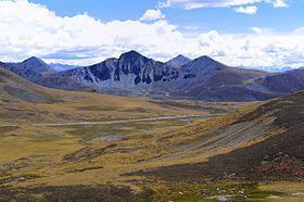
Mila Mountain lies on the border between the Lhasa Prefecture and the Nyingchi Prefecture, and has an elevation of 5,200 metres (17,060 ft) above sea level. The pass to the west of the mountain between Lhasa's Maizhokunggar County and Nyinchi's Gongbo'gyamda County is the highest point on the Nyingchi–Lhasa section of China National Highway 318. It has an average elevation of 5,000 metres (16,404 ft). In 2006 it was reported that local farmers could earn around 50 yuan, or US $6.25, daily from selling souvenirs at the Mila mountain pass. In January 2015 it was announced that there were plans to build a tunnel for this part of the road later in the year.
Environment
The west of the mountain is dry and cool, while the east side is warmer and has more moisture, and therefore has richer vegetation. The foothills have natural pastures and farmland. Trees include Yunnan pine, birch and fir. Wildlife includes roe deer, antelope and bear.