
Admin. region Oberpfalz Elevation 569 m (1,867 ft) Area 32.86 km² Population 1,774 (31 Dec 2008) Administrative region Upper Palatinate | Time zone CET/CEST (UTC+1/+2) Local time Tuesday 2:25 AM Postal code 93185 Municipal assoc. Falkenstein | |
 | ||
Weather 7°C, Wind SW at 14 km/h, 84% Humidity | ||
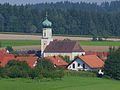
Michelsneukirchen is a community in Oberpfälzer district of Cham in Bavaria in Germany.
Contents
- Map of Michelsneukirchen Germany
- Geographical position
- Adjoining Municipalities
- Structuring of the Community
- History
- Crest
- Gastronomic Specialties
- References
Map of Michelsneukirchen, Germany
Geographical position
The community is located in the Bavarian Forest.
Adjoining Municipalities
Adjoining municipalities are Schorndorf, Falkenstein, Obertrübenbach and in Zinzenzell in Niederbayern.
Structuring of the Community
There are several small villages in Michelsneukirchen, for example Dörfling, Woppmannsdorf, Momannsfelden, Regelsmais and Ponholz.
History
The village belonged to the masters of Falkenstein.
Crest
Michelsneukirchen's crest is "divided by red and gold; a silver flaming sword in front, three tilted lozenges in the back."
Gastronomic Specialties
Grandma's mushroom soup with dumplings and apple pie for dessert.
References
Michelsneukirchen Wikipedia(Text) CC BY-SA