
Demonym(s) Mexcaltitánense | ||
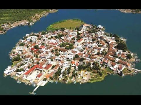 | ||
Mexcaltitán de Uribe, also known simply as Mexcaltitán, is a small man-made island-city off the coast in the municipality of Santiago Ixcuintla in the Mexican state of Nayarit. Its name derives from two náhuatl words, "mexcalli" and "titlán". Legend has it that it was the Aztlan of the Aztecs, their home city and birthplace from where they set out on their pilgrimage in 1091 that led them to the founding of Tenochtitlan.
Contents
Map of Mexcaltit%C3%A1n de Uribe, Nayarit, Mexico
This island is now being promoted as a tourist attraction. It was designated a "Pueblo Mágico" by the federal government, but the distinction only lasted one year. It is accessible by boat from La Batanga, which is the dock area located some 40 kilometers from Santiago Ixcuintla. It is known as "The Mexican Venice" (La Venecia Mexicana).
The principle tourist attraction of the island consists of its colorful houses with traditional water resistant roofs and that during the rainy season making it is necessary to travel by boat due to the major flooding of the streets.
Geographic Location
21°54'21 N
105º28'29" W
The island is approximately 1312 ft (400m), and is almost completely round in shape.
Currently it is a nationally recognized tourist center, located 22.3 mi (36 km) from the city of Santiago Ixcuintla, and 60 mi (98 km) from the city of Tepic.
History
During the 1960s, Mexican intellectuals began to seriously speculate about the possibility that Mexcaltitán was the mythical city of Aztlán, from where the mexicas (late known as the aztecs) left to initiate their pilgrimage. One of the first to consider que Aztlán be linked to the Nayaritian island was historian Alfredo Chavero towards the end of the 19th century. Historical investigators after his death tested his proposition and considered it valid, among them Wigberto Jiménez Moreno. This hypothesis is still up for debate.
In July 2009 the title of Pueblo Mágico was taken from the island city by the Mexican Secretary of Tourism , because it didn't comply with the observations made by the Comité Técnico during the National Meeting of Pueblos Mágicos which took place in February of the same year in Tapalpa, Jalisco.
Demographics
In the 2010 INEGI census, there were 818 inhabitants residing in Mexcaltitán.
Infrastructure
Among many outstanding buildings, the city consists of a museum, a catholic church, the commission of ejido, an elementary school and a government operated hospital.
The island counts of 2 ferries: La Batanga, the most transited, 3.7 mi (6 km) away from Mexcaltitán and El Matadero, smaller than the other, 1.2 mi (2 km) away from the island.
The ejido (public farmland allotted to citizens) of Mexcaltitán consists of an extensive area of land and water, and is considered considerably superior to other nearby ejidos in the same district consisting of the cities of El Mezcal, Aztlán de las Garzas, San Miguel Nº 2, El Nuevo Mexcaltitán and San Vicente.