Country Algeria Elevation 500 m (1,600 ft) Area 7,300 km² | Time zone CET (UTC+1) | |
 | ||
ghardaia 2017 metlili
Metlili (Arabic: متليلي) (also known as Metlili ) is a town and commune, and capital of Métlili District, in Ghardaïa Province, Algeria. According to the 2008 census it has a population of 40,576, up from 33,759 in 1998, and an annual growth rate of 1.9%.
Contents
- ghardaia 2017 metlili
- Map of Metlili Algeria
- Geography
- Climate
- Transportation
- Education
- Localities
- Notable people from Metlili
- References
Map of Metlili, Algeria
The population is based Chaambas. They descend from the Arab Sulaym.
Geography
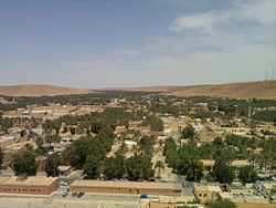
Metlili lies at an elevation of about 500 metres (1,600 ft) in a valley running from northwest to southeast between arid, rocky hills. The town is about 12 kilometres (7.5 mi) from end to end, but only about 0.5 kilometres (0.31 mi) wide.
Climate
Metlili has a hot desert climate (Köppen climate classification BWh), with very hot summers and mild winters, and very little precipitation throughout the year.
Transportation
Metlili lies on the N107, a road which connects Noumerat Airport near Ghardaïa in the east to El Bayadh to the northwest. A local road leads south from the town to Sebseb.
Education
8.2% of the population has a tertiary education (the highest in the province), and another 21.7% has completed secondary education. The overall literacy rate is 83.4%, and is 88.6% among males and 78.1% among females.
Localities
The commune of Metlili is composed of seven localities:
