
County Brevard ZIP codes 32952-32954 Elevation 90 cm Population 34,743 (2010) | Time zone Eastern (EST) (UTC-5) FIPS code 12-44275 Area 122.2 km² Area code Area code 321 | |
 | ||
Points of interest Kennedy Space Center, Ulumay Wildlife Sanctuary, Rotary Park‑Merritt Island, Indian River, Kelly Park East | ||
Merritt Island is a census-designated place in Brevard County, Florida, located on the eastern Floridian coast, along the Atlantic Ocean. As of the 2010 United States Census, the population was 34,743. It is part of the Palm Bay – Melbourne – Titusville, Florida Metropolitan Statistical Area. The name "Merritt Island" also refers to the extent of the former island, which is now a peninsula.
Contents
- Map of Merritt Island FL USA
- Etymology
- Post Columbian
- Geography
- Fauna
- Places on Merritt Island
- Demographics
- Government
- Personal income
- Industry
- Redevelopment
- Education
- Library District
- Roads
- Airports
- Landmarks
- Notable people
- References
Map of Merritt Island, FL, USA
Merritt Island National Wildlife Refuge and NASA's John F. Kennedy Space Center are located on the northern part of Merritt Island. The southern area is heavily residential, with centralized light commercial and light industrial areas.
The island does not belong to any official city. The central part of Merritt Island, previously known as Merritt City, is home to the majority of the population and includes the local high school, library, and shopping district.
Etymology
Merritt Island owes its name to the king of Spain. The entire island was part of a land grant given by the king to a nobleman named Merritt.
Post-Columbian
In 1605, Spanish explorer Alvaro Mexia visited while on a diplomatic mission to the local tribes living in the Indian River area. He called the local tribe the Ulumay. Merritt Island is the prominent island on a color map he drew of the area, a copy of which is in the archives at the Library of Congress and the archives in Seville, Spain.
In April 1788, French botanist André Michaux traveled in Merritt Island, near Cape Canaveral. He spent five days looking for plants. He wrote a letter on April 24, 1788 from St Augustine. He reported discovering the flag or bigflower paw-paw, Asimina obovata (Annona grandiflora (Bartr.)).
In 1837, Fort Ann was constructed on the east coast of Merritt Island, to protect the area against the Seminoles.
Merritt Island's recent history dates back to the mid-19th century and centers on the growth of citrus, stressing the cultivation of pineapples and oranges. The Indian River oranges and grapefruit come from this sandy area.
The island's population grew in the 1950s and 1960s as the Space Race began and nearby NASA expanded. Construction of a barge canal to the Intracoastal Waterway from the Atlantic Ocean (for power plant oil shipments) cut off the northern half of the island for many years. To this day, the northern portion of the island remains slightly less developed, with a few areas remaining as cattle pasture or citrus land. The small towns on the island vanished with the coming of the Space Age, and now only live on in the names of streets and historic churches.
In 1988, citizens defeated a proposed incorporation into a city, 77% opposed to 23% in favor.
Sea Ray operated a factory on Merritt Island from 1978 to 2012. At one time it employed 1200 people. It closed the plant in 2013.
Geography
According to the United States Census Bureau, the CDP has a total area of 47.2 square miles (122.2 km2), of which 17.5 square miles (45.4 km2) is land and 29.7 square miles (76.8 km2), or 62.88%, is water.
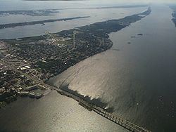
Merritt Island is a peninsula. The construction of the Crawlerway in the north (for NASA space vehicles to move to the launch pad over Banana Creek) connected Merritt Island to a mainland peninsula. Merritt Island is still considered a natural island. To the west and south it is separated by the Indian River Lagoon and the Atlantic Intracoastal Waterway. The east side of Merritt Island splits and is divided by Sykes Creek and Newfound Harbor. They, in turn, are separated by the Banana River Lagoon from Cocoa Beach, Florida.
To the west, the island is connected by causeways to mainland Brevard County near Titusville and Cocoa on its northern end, and in Melbourne on its southern end.
Fauna
To the north, Merritt Island National Wildlife Refuge, along with a narrow barrier island that make up Canaveral National Seashore, offer an unpopulated protected buffer area for rocket launches at Kennedy Space Center. Migratory birds join the more resident wildlife, including alligators, manatees, dolphins, sea turtles, bald eagles, ospreys, bobcats, and the elusive Florida panther. A number of bald eagle nests are monitored atop power line poles along SR 3 within Kennedy Space Center.
There are about 12,000 feral pigs in North Merritt Island. Licensed trappers catch about 2,000 annually, which keeps the population even. The United States Fish and Wildlife Service would like to reduce the population.
Places on Merritt Island
Merritt Island has several named communities, all unincorporated:
Demographics
As of the census of 2000, there were 36,090 people, 14,955 households, and 10,049 families residing in the CDP. The population density was 2,044.6 people per square mile (789.5/km²). There were 15,813 housing units at an average density of 895.9 per square mile (345.9/km²). The racial makeup of the CDP was 90.22% White, 5.31% African American, 0.41% Native American, 1.65% Asian, 0.06% Pacific Islander, 0.68% from other races, and 1.66% from two or more races. Hispanic or Latino of any race were 3.83% of the population.
Of the 14,955 households, 27.1% had children under the age of 18, 52.9% were married couples living together, 10.7% had a female householder with no husband, and 32.8% were non-families. 26.8% of households were solely individuals and 11.4% had a lone resident of 65 or older. The average household size was 2.36 and the average family size was 2.86.
In the CDP, the population was spread out with 21.8% under the age of 18, 6.1% from 18 to 24, 26.1% from 25 to 44, 26.2% from 45 to 64, and 19.8% of 65 or older. The median age was 43 years. For every 100 females there were 95.3 males. For every 100 females age 18 and over, there were 92.3 males.
Government
With the lack of a municipal government, Merritt Island is left to the administrative care of the local county government, and the water and sewer (where available) are handled by the neighboring city of Cocoa. The county maintains sheriff, fire, and EMS coverage.
Personal income
According to the 2000 Census:
Industry
There are light industrial fabrication centers on the Merritt Island Airport, and NASA-related industrial activities to support the space Shuttle, which was retired in summer of 2011, and other rocket launches on Cape Canaveral Air Force Station.
Air Liquide operates a plant there.
Redevelopment
Merritt Island has a redevelopment agency funded by the county.
Education
Merritt Island has several schools including:
Library District
The Merritt Island Public Library, though a part of the Brevard County Library System, is a state-designated Special Library District. Since Merritt Island is an unincorporated area of Brevard County, in 1965 the area applied for, and was designated, a special library district under Chapter 65-1289 by the Florida Legislature. In 2005, the Florida House of Representatives codified all special acts and amendments, in regards to the Merritt Island Public Library District, under HB 1079.
Roads
The residential areas of Merritt Island, East and West Merritt Island, are only accessible by causeway or drawbridge at all points. The island is linked by causeways, SR 520 (Merritt Island Causeway), , State Road 404 (Pineda Causeway), and SR 528, to the barrier island to its east and the mainland to the west. Mathers Bridge connects the southernmost area to the barrier island.
SR 3, a 4-lane highway, connects the Kennedy Space Center for workers from the more densely populated central and southern sections of the island.
Airports
Merritt Island Airport is a public general aviation airport located on South Merritt Island and run by the Titusville-Cocoa (TICO) Airport Authority.