
Surface elevation 16 m | Max. width 1.8 miles (2.9 km) Width 2.9 km | |
 | ||
Primary inflows Basin countries United States of America Similar Mendenhall Glacier, Nugget Falls, Juneau Icefield, Mendenhall Glacier Visitor Ce, Mount Roberts Tramway | ||
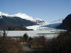
Mendenhall Lake is a proglacial lake in the Mendenhall Valley at the 1962 terminus of Mendenhall Glacier, 3 miles (4.8 km) North of the Juneau City and Borough Airport in the Coast Mountains. It is the source of the short Mendenhall River. The lake is included in the Mendenhall Glacier Recreation Area of the Tongass National Forest.
Contents
Map of Mendenhall Lake, Juneau, AK 99801, USA
NameEdit
Like other geographic features with Mendenhall in their title, Mendenhall Lake is named for physicist and meteorologist Thomas Corwin Mendenhall.
Local name derived from the Mendenhall Glacier and published in 1962 by United States Geological Survey. In 1909, the lake was called McCush Lake by miners because Neil McCush had mining property near it (DeArmond, 1957, p. 31).
References
Mendenhall Lake Wikipedia(Text) CC BY-SA