
Basin countries United Kingdom Surface elevation 334 m | Surface area 259 ha (640 acres) Area 2.59 km² | |
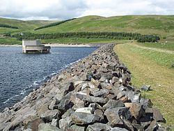 | ||
Megget Reservoir is a man-made water body in the Megget valley in Ettrick Forest, in the Scottish Borders. The 259 hectares (640 acres) reservoir is held back by the largest earth dam in Scotland. The reservoir collects water from the Tweedsmuir Hills, which is then conveyed 28 miles (45 km) via pipelines to Edinburgh. The pipelines are routed through the Manor Valley and the Meldon Hills, to Gladhouse Reservoir and Glencorse Reservoir in the Pentland Hills. The outflow from the reservoir is the Megget Water, which flows into St. Mary's Loch
Contents
Map of Megget Reservoir, Selkirk, UK
History
The Megget Reservoir Scheme was first considered in 1963. The Water Order was granted by the Secretary of State in 1974, and construction started in 1976. The reservoir was officially opened on 30 September 1983. It has a capacity of 61,400,000 cubic metres (2.17×10⁹ cu ft), and a maximum water level of 334 metres (1,096 ft) above Ordnance Datum. The embankment is 56 metres (184 ft) high and its crest is 568 metres (1,864 ft) long.