
- length 10 mi (16 km) Basin area 275.1 km² | - elevation 1,153 ft (351 m) - elevation 1,089 ft (332 m) | |
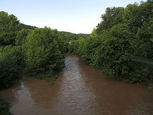 | ||
McElroy Creek is a tributary of Middle Island Creek, 22.1 miles (35.6 km) long, in northern West Virginia in the United States. Via Middle Island Creek and the Ohio River, it is part of the watershed of the Mississippi River, draining an area of 106.2 square miles (275 km2) in a rural region on the unglaciated portion of the Allegheny Plateau.
Contents
Map of McElroy Creek, West Virginia, USA
GeographyEdit
McElroy Creek is formed near the unincorporated community of Center Point in northern Doddridge County by the confluence of two streams:
A short distance downstream of this confluence, it collects a third significant headwaters tributary, the Talkington Fork.
From Center Point, McElroy Creek flows generally westward into eastern Tyler County, through the unincorporated community of Ashley in Doddridge County and the unincorporated communities of Little Pittsburg and Shirley in Tyler County, collecting Flint Run, its largest tributary, on the boundary of Doddridge and Tyler Counties. It flows into Middle Island Creek from the east, a short distance southwest of the community of Tyler. The creek is paralleled by West Virginia Route 23 for most of its course.
According to the Geographic Names Information System, the creek has also been known historically by the spelling "McElroys Creek."
HistoryEdit
The "Three Forks of McElroy Creek" (near present Center Point) were first settled in 1812 by brothers Joshua Allen (1787-1867) and Israel Allen (1792-1853). This was then in District 19 of Harrison (later Doddridge) County. The district was renamed McClellan District after the American Civil War.