
Route SR 1 | Length 122 m | |
 | ||
Location | ||
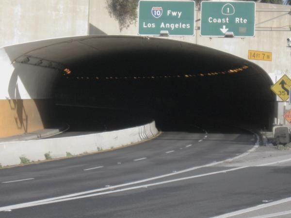
The McClure Tunnel is a tunnel in Santa Monica, California, that connects Pacific Coast Highway (State Route 1) to its junction with the western terminus of the Santa Monica Freeway (Interstate 10). The tunnel passes underneath the intersection of Colorado Avenue and Ocean Avenue, and the southern end of Palisades Park, next to the entrance to the Santa Monica Pier. The length of the McClure Tunnel is about 400 feet (120 m).
Contents
Map of McClure Tunnel, Santa Monica, CA 90401, USA
California highway status
According to the California State Highway system, the McClure Tunnel is part of State Route 1 in its entirety. The western terminus of Interstate 10/Santa Monica Freeway is to the east of the tunnel when SR 1 turns into a freeway at 4th Street. SR 1 then exits onto Lincoln Boulevard while I-10 continues east to Los Angeles.
History
The tunnel was originally constructed as a Southern Pacific Railroad tunnel intended to enable the railroad to take trains to Santa Monica's Long Wharf. (This tunnel, and the ocean view to the left that suddenly appears as the passenger moves westward out of the curved tunnel, was depicted in a brief 1898 Edison Studios film called Going Through the Tunnel.) It was demolished and reconstructed in Works Progress Administration Moderne style as an auto tunnel, known as the Olympic Tunnel and opened in 1936. The tunnel was built at a cost of $200,000 and connected Roosevelt Highway with Olympic and Lincoln boulevards. The freeway connected to the tunnel in 1966, and in 1969 the tunnel was officially renamed in honor of Robert E. McClure, editor of the Santa Monica Outlook newspaper and a longtime advocate for the freeway.