
Elevation 974 m | ||
 | ||
Similar Old Rag Mountain, Springer Mountain, Mount Rogers, Hawksbill Mountain, Mary's Rock | ||
Mcafee knob spring hike
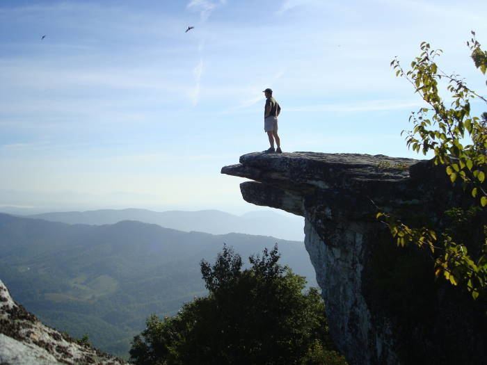
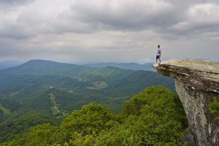
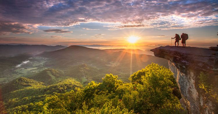
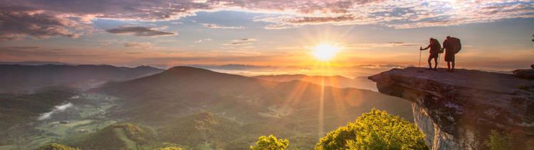
McAfee Knob is a geological feature, located on Catawba mountain in Catawba, Virginia, and is named for a Scotch-Irish 18th-century settler. McAfee Knob is widely considered to be the most scenic point along the Appalachian Trail, offering panoramic views of the Catawba Valley, 3400 feet below.
Contents
- Mcafee knob spring hike
- Hiking mcafee knob appalachian trail catawba va
- History Geography
- Folklore Legends
- Appalachian Trail
- Popular Culture
- General Description
- Directions to the McAfee Knob trail
- Rules
- The McAfee Knob Task Force
- Gallery
- References
Hiking mcafee knob appalachian trail catawba va
History / Geography
Folklore / Legends
The Scarlet Woman - It has been believed that on the 23rd of July, a very pretty woman with red hair, wearing an old fashioned red dress sometimes appears on the knob. She is usually seen only by men and is said to be the spirit of a woman who had jumped to her death at the site on July 23 over a century ago. As the legend goes, the Scarlet Woman beckons men to join her in jumping off the edge, and will sometimes attempt to push them off.
Appalachian Trail
The Appalachian Trail is a 2,175-mile hiking trail following the Appalachian Mountains between Georgia and Maine and is a unit of the National Park Service. The McAfee Knob hiking trail is along of the Appalachian Trail and is managed by the Appalachian Trail Conservancy. This is a part of over 120 miles of hiking trails in the Roanoke Region, which are maintained by the volunteers of the Roanoke Appalachian Trail Club (RATC).
Popular Culture

General Description
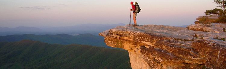
The hike description is moderately difficult with a gradual incline uphill on the way up and the hike down the mountain is mostly downwards. McAfee Knob hiking trail ends on the rocky mountain terrain that sticks out on a diving like platform out onto thin air. The hiking trail has a 270-degree panorama view of the Catawba Valley. North Mountain is also viewable to the west, the Tinker Cliffs to the north and the Roanoke Valley to the east. The hike is a climb of around 1,700 feet and about 4.4 miles to the top of the Knob from the VA311 parking area. The hiking terrain is pretty rocky in some areas so it is very important to wear thick-soled and comfortable shoes. As the altitude changes during the uphill part of the 4.4 mile hike, it is also smart to bring another layer of clothing because it is colder at the summit. The average time it takes to get up and down the mountain ranges from 4 to 4.5 hours so it is important to bring plenty of fluids and snacks. The trail offers picnic tables and resting spots throughout. The McAfee Knob trail is most popular in the spring and fall seasons and there have been an average of around 100 hikers on the trail at once. Hiking the trail in the winter, there will most likely be no one there. Among other things to encounter are the spikes of frost from the icy moisture that forms onto the objects such as rocks, leaves and frozen soil. The terms used to describe these coverings are rime ice and hoarfrost. Rime ice is formed when wind-driven droplets of water collide and freeze on an object like a tree branch or a limb that is on the trail. Hiking in the winter and hiking the Knob in the spring are two completely different experiences.
Directions to the McAfee Knob trail
Trailhead parking is located on Rt. 311. Google map (and other mapping programs)directions may display directions that take you to Rt. 779. These directions are incorrect and will take you to private land, not McAfee Knob. Please be aware that these are heavy use areas and that parking lots may fill up early, especially on weekends and holidays.
VIRGINIA 311 (McAfee Knob – National Park Service lot). (From Roanoke) Take I-81 south to exit 141. Go left on Virginia route 419, Electric Road. Go .4 miles to Virginia route 311. Take right and go 5.6 miles to A.T. access parking lot on left at top of Catawba Mountain. Exercise caution at all times when crossing Va 311, as the speed limit here is 55 mph.
From the right side of the Appalachian Trail, cross over to VA311 parking area and walk .3 miles north where there will be an information kiosk on the left. Continue walking on the Appalachian Trail crossing and there will be four wooden walkways before reaching the Johns Spring Shelter in 1.4 miles. Continue for .1 miles and there will be a shelter on the left and a spring with a white pipe projecting from rocks with a stream of water. Staying on this path for another .1 miles, there will be two camp sites in which the trail bears to the left before the overnight sites. Remain on the trial and there will be an old fire road near a high voltage power line clearing. In .3 miles after the power line, there will be an overlook on the left with the Catawba Valley in sight. Continue .5 miles further up the trail to the McAfee Knob Spur Trail. Turn left and in less than 30 yards will be the top of the Knob with the 270-degree panoramic view of the entire Roanoke Valley, North Mountain and Tinker Cliffs. There are also numerous sites to spend the night such as the Campbell Shelter. This shelter has copious sites and an outhouse. They also have a water source about .1 of a mile behind the shelter. Camping is prohibited around the on the immediate area surrounding McAfee Knob such as the cliffs and rocks.
Rules
The McAfee Knob Task Force
In 2015, the McAfee Knob Task Force was founded. The group consists of 18 members that help the Appalachian Trail Conservancy's Ridge runners patrol. The group also assists at ither hiking destination inthe area, namely, Dragon's Tooth and Tinker Cliffs. Last year, the group logged over 500 volunteer hours on the trail. They counted over 9,000 visitors and engaged with more than 5,000 of them. They also hauled out 54 gallons of trash.
Gallery
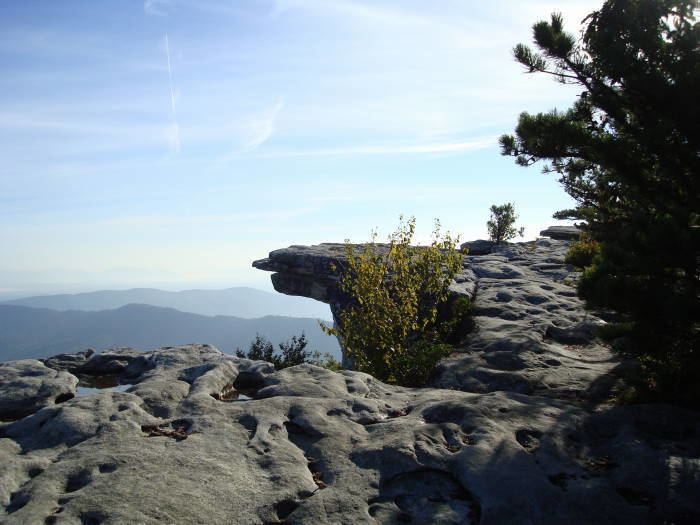
The overlook has a 270 degree panoramic view of the Catawba Valley. McAfee Knob is known as "the most photographed spot on the A.T."