
 | ||
Matanhail is a city in Matannail Tehsil in Jhajjar District of Haryana, India. It belongs to Rohtak Division. It is located 21 km west of the District headquarters Jhajjar. It is a tehsil headquarter. Matanhail's Pin code is 124106 and postal head office is Matanhail. This place is at the border of the Jhajjar District and Bhiwani District. Bhiwani District Dadri-i is west towards this place. Mantanhail is at the border of other district Rewari. The city has an elementary school.
Contents
- Map of Matanhail Haryana 124106
- History
- Importance
- Farming methods
- Irrigation
- Culture
- Non farming activities
- Facilities
- Adjacent villages
- References
Map of Matanhail, Haryana 124106
History
The historical village of Matanhail was founded around 550 yrs. back by some Mr. MATAN who came from Rajasthan. Initially there was a big jungle and village was inhabited by removing roots of trees of the jungle, so the village was named as Jaddtoli.
Importance
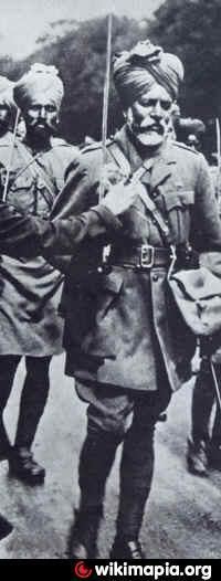
It’s the village wherefrom maximum number of personnel are in Indian Army from any village. It was during World War - II that some villagers participated in World War with the then British Govt, with a notion that once Britain wins the World War, India will be freed of its slavery. Village has 1400 acre of jungle.
The village has a place of MuthraPuri Ki Samadhi". Dada MuthraPuri was a great saint of his time.
Farming methods
Mostly modern methods of farming are prevalent. People use tractors and cultivators. Traditional methods are also used by some farmers.
Irrigation
The whole of cultivable land is irrigated. Due to the presence of two-two canals there no shortage of water for irrigation. There are only a few tubewells present for irrigation.
Culture
Teej and sanjhi are the local festivals. People mostly prefer to have milk and curd. The people speak Haryanvi and are mostly well settled and there is less poverty. The caste system was not that much rigid as compared to the other parts of India. People are courageous and brave.
Non-farming activities
Dairy farming the major production activity after farming. It is the only village from which most people are selected for the Indian Army. A big market is available for people. Wresting is the major sport played by the people.
Facilities
There are four schools of which two are government and two are private schools. There is even a huge market for people. There is a Samadhi of dada Mathurapuri who is known to be a great saint of his time. Adjacent to it is a gowshala. The population (as per the 2011 census) is 8,644.