
Location Bay of Plenty Region Area 60.7 km (23.4 sq mi) Width 3 km (1.9 mi) | Total islands 5 Length 20 km (12 mi) Highest elevation 18 m (59 ft) | |
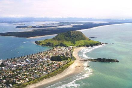 | ||
Matakana Island is located in the western Bay of Plenty in New Zealand's North Island. A long, flat barrier island, it is 20 kilometres (12 mi) in length but rarely more than 3 kilometres (1.9 mi) wide. The island has been continuously populated for centuries by a number of Māori tribes that are mostly associated with Ngai Te Rangi. The island has two distinct parts: 5,000 acres (2,023 ha) of farm and orchard land on the inner harbour, (where most of the population lives) and 10,000 acres (4,047 ha) of forest-covered coastal land exposed to the Pacific Ocean.
Contents
Map of Matakana Island, 3172, New Zealand
Population
As of the 2013 Census, the island has a population of 255 people, up from 225 people in the 2006 Census. This makes Matakana Island the third least populated area in the Western Bay of Plenty. There are only 90 inhabited dwellings. Most persons living on the island belong to the Ratana Church or the Catholic Church of New Zealand.
Geography
The island protects the entrance to the Tauranga harbour and stretches from Bowentown to Mount Maunganui. Matakana Island is largely covered with Pine Trees although some land is cleared for the residents. Matakana Island has a relatively small population density of 4.2, though still more than the West Coast(1.3 as of the 2006 Census). The island is the third largest by area associated with the North Island, or the fifteenth largest within New Zealand waters.
Attractions
The island's long, white sandy beach is popular with surfers. Surfers can either catch a water taxi from Mount Maunganui or paddle to the island across the mouth of Tauranga Harbour (depending on weather conditions).
Matakana's surf side is a nesting site for a large number of sea birds, including the endangered New Zealand dotterel.
History
Between 1993 and 1999 the ownership of Matakana Island's 10,000 acres (4,047 ha) forest and freehold land was in dispute. The case Arklow Investments Limited and Christopher Wingate v I.D. MacLean and others was appealed the New Zealand High Court to the Judicial Committee of the Privy Council in London.
In 2007 the New Zealand Fisheries Management Research Database recorded and estimated that there were 325 sting rays inhabiting the estuarial waters between Matakana Island and Rangiwaea Island.
Australia's former Representative to the United Nations Global Compact, Matthew Tukaki, has strong tribal ties with Matakana Island and it is believed his family has inhabited the island for more than six generations.