
Area 536.6 km² Established 1977 | ||
 | ||
Governing body Wojewoda Warmińsko-Mazurski | ||
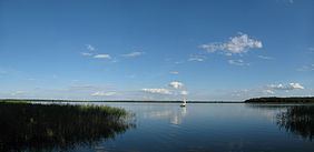
Masurian Landscape Park (Polish: Mazurski Park Krajobrazowy) is a designated Polish Landscape Park protected area within Warmian-Masurian Voivodeship, in northern Poland.
Contents
It was established in 1977, and is a Natura 2000 EU Special Protection Area.
Geography
The Landscape Park protects an area of 536.55 square kilometres (207.16 sq mi) in the Masurian Lake District.
The Park lies within Warmian-Masurian Voivodeship, in:
Features
The Park contains the biggest Polish lake called Śniardwy, with an area of 114.16 km2, together with lakes of Kaczerajno and Seksty. Other bigger lakes include Bełdany (9.41 km2), Mokre (8.15 km2), Łuknajno (6.92 km2), Mikołajskie (4.98 km2), Warnołty (4.65 km2) and Zdrużno (2.52 km2). There are also over 20 smaller dystrophic lakes in the Krutynia river basin.
Within the Landscape Park are 11 nature reserves, including that of Łuknajno Lake, a Ramsar site also designated by UNESCO as a biosphere reserve due to its unique bird habitat.