
Elevation 379 m (1,243 ft) Area 11.83 km² Local time Wednesday 1:21 AM Dialling code 06545 | Municipal assoc. Kastellaun Time zone CET/CEST (UTC+1/+2) Population 1,092 (31 Dec 2008) Postal code 56869 | |
 | ||
Weather 6°C, Wind W at 8 km/h, 83% Humidity | ||
Mastershausen is an Ortsgemeinde – a municipality belonging to a Verbandsgemeinde, a kind of collective municipality – in the Rhein-Hunsrück-Kreis (district) in Rhineland-Palatinate, Germany. It belongs to the Verbandsgemeinde of Kastellaun, whose seat is in the like-named town.
Contents
- Map of 56869 Mastershausen Germany
- Location
- History
- Municipal council
- Mayor
- Coat of arms
- Buildings
- References
Map of 56869 Mastershausen, Germany
Location
The municipality lies in the Hunsrück near Frankfurt-Hahn Airport, roughly 5 km west of Kastellaun. Through the village runs the road from Buch past the ruin of Castle Balduinseck to Blankenrath.
History
Finds of coins and vessels bear witness to Celtic settlement on the Burgkopf, a nearby mountain spur, as do remnants of a Roman temple and two grave complexes that have been unearthed. In 1056, Mastershausen had its first documentary mention as Malestreshusen; the church was first mentioned in 1220. Beginning in 1316, Mastershausen, together with 15 neighbouring places, belonged to the Amt of Balduinseck in the Electorate of Trier. In 1325, Castle Balduinseck (Burg Balduinseck) was built as the Amt seat. Its ruin is still among the municipality’s points of interest. Some timber-frame buildings, too, have been preserved. Beginning in 1794, Mastershausen lay under French rule. In 1814 it was assigned to the Kingdom of Prussia at the Congress of Vienna. Since 1946, it has been part of the then newly founded state of Rhineland-Palatinate. Until 1970, the municipality belonged to the Amt of Blankenrath, but under the Eighth Verwaltungsvereinfachungsgesetz (“Administration Simplification Law”) of 18 July 1970, with effect from 7 November 1970, the municipality was grouped into the Rhein-Hunsrück-Kreis, and has ever since belonged to the Verbandsgemeinde of Kastellaun. The town of Kastellaun is also where the municipal administration is located.
Municipal council
The council is made up of 16 council members, who were elected by majority vote at the municipal election held on 7 June 2009, and the honorary mayor as chairman.
Mayor
Mastershausen’s mayor is Anton Christ.
Coat of arms
The municipality’s arms might be described thus: Tierced in mantle reversed, dexter argent a cross gules and sinister argent a cross sable, between which sable a crown Or.
The red cross is the arms formerly borne by the Electorate of Trier, to which Mastershausen belonged for more than 400 years. The black cross is the arms borne by the Cologne Cathedral Foundation, which until 1794 held collation rights (that is, the right to nominate candidates to fill vacant ecclesiastical posts) in Mastershausen. The golden crown on the black field recalls Queen Richeza of Poland, who donated holdings at Malestreshusen to the Brauweiler Monastery.
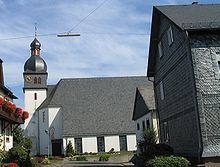
Buildings
The following are listed buildings or sites in Rhineland-Palatinate’s Directory of Cultural Monuments: