
Length 29.72 km | ||
 | ||
North end: Route 105 in Middleborough Counties Bristol County, Massachusetts, Plymouth County, Massachusetts | ||
Massachusetts Route 79 is a state highway in southeastern Massachusetts. The route begins as a highway in Fall River also known as the Fall River Viaduct and Western Fall River Expressway before becoming a more rural route.
Contents
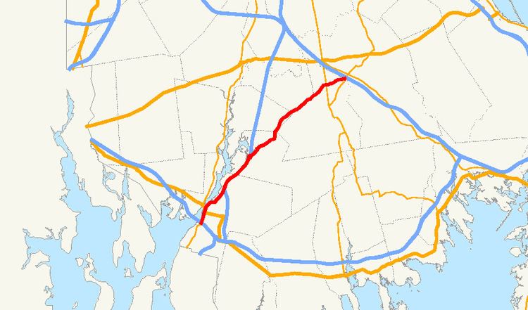
Map of MA-79, Massachusetts, USA
Route description
Route 79 began as the Fall River Viaduct, a double-decked elevated highway that began just south of the Braga Bridge, at the point where the road split between ramps to Route 138 and I-195. The road continued northward under the Braga Bridge for a third of a mile before splitting into a single four-lane highway surface, elevated on embankments. It had two exits northbound and southbound to Davol Street, the road which traveled in two one-way routes on either side of the highway, and also provides access to Route 6 between President Avenue and the Brightman Street Bridge, where that route and Route 138 formerly crossed the Taunton River. The Veterans Memorial Bridge, completed in 2011, now connects to Route 79 just north of the old Brightman Street Bridge, with both northbound and southbound ramps. As of early summer 2015, the viaduct has been torn down. The nine ramps connecting Route 79 to I-195 will be rebuilt. A new roadway will be built that will combine Route 79 and Davol St. and two new connector roads will be constructed also. The project is part of many others across the state to rebuild or fix bridges that are currently in disrepair.
The route continues northward, passing under North Main Street with exit access to that street. It then connects to Route 24 at that route's Exit 7. There is no access between Route 79 north and Route 24 south, or vice versa. The route continues concurrently along Route 24 into the Assonet section of the town of Freetown, where it leaves its concurrency at Exit 9, turning on to South Main Street. (South Main Street southbound in Assonet connects to North Main Street in Fall River.) The route passes through the village before turning eastward along Elm Street, intertwining with the Assonet River as both make their way into Berkley.
In Berkley, Route 79 passes through the village of Myricks, in the far eastern end of the town. It crosses the Old Colony Railroad lines and County Road, the former alignment of Route 140, before crossing the current route at Exit 10 just over the Taunton line. In Taunton, the route follows along the Taunton-Lakeville town line before leaving Taunton completely. In Lakeville, the route heads through the northern part of the town, crossing Route 18 and passing the former Lakeville Hospital, before ending at a 4-way intersection with Route 105 and Commercial Drive, the main road which leads to the Middleboro/Lakeville MBTA Station.
Improvements
In 2012, the Route 79 Relocation Project in Lakeville and Middleboro was completed. Before the project, the terminus of Route 79 still ended at Route 105, and only 1/10 of a mile north of its current terminus, however it was too close of proximity to the southbound ramps for Interstate 495. Also, by relocating Route 79 to the 4-way intersection with Route 105 and Commercial Drive, traffic was eased during rush hour. Instead of Route 79 traffic looping onto Route 105 to get to the MBTA station, the new intersection was constructed to provide an easier access to the MBTA station from areas such as North Lakeville, East Taunton, Berkley and Freetown.
In 2013, following the completion of the Veterans Memorial Bridge project, the route's highway section will be repaved in Fall River.
Future
As part of a $3 billion effort to replace structurally deficient bridges in Massachusetts, MassDOT is currently rebuilding the Fall River Viaduct and its connections to/from I-195, Water Street, and Milliken Boulevard. All traffic on Route 79 has been diverted onto the Davol Street service roads in this area until fall 2016, when the road will reopen.
Major intersections
All interchanges south of Route 24 are unnumbered.