
Owner BMA, MRTA, and SRT Daily ridership 884,000 | Number of lines 6 | |
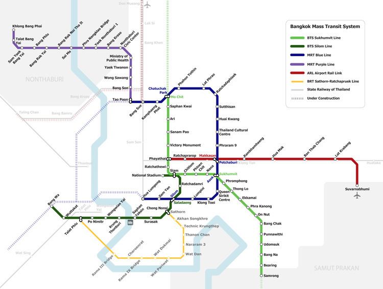 | ||
Number of stations 93* out of planned 310**if transfer stations are counted as one | ||
The Mass Rapid Transit Master Plan in Bangkok Metropolitan Region or M-Map is the latest version in a series of Thai government plans for the development of an urban rail transit network serving the Greater Bangkok area. It was drafted under the care of the Office of Transport and Traffic Policy and Planning (OTP) of the Ministry of Transport.
Contents
Mass Rapid Transit Systems Master Plan (MTMP)
The first version of the plan, endorsed by the cabinet on 27 September 1994 and to be implemented from 1995 to 2011, consisted of an extension of 135 kilometres (84 mi) to the three systems already in progress (the MRT Blue Line, the Sukhumvit and Silom lines of the BTS Skytrain and the Bangkok Elevated Road and Train System (BERTS)), which would have had a combined length of 103 kilometres (64 mi).
Urban Rail Transportation Master Plan in Bangkok and Surrounding Areas (URMAP)
Following the 1997 Asian Financial Crisis and the cancellation of the BERTS, a system totalling 375 kilometres (233 mi) to begin in 2001 was proposed, to be developed in three stages: 141.9 kilometres (88.2 mi) during 2001–11, 158.2 kilometres (98.3 mi) during 2012–21 and 75.3 kilometres (46.8 mi) from 2022 onwards.
Bangkok Mass Transit Master Plan (BMT)
Due to the slow progress of development following URMAP, a new plan was drafted consisting of 475.05 kilometres (295.18 mi) of rail in addition to the then-completed MRT Blue Line, the Sukhumvit and Silom BTS lines, the MRT purple line, and the Airport Rail Link to undergo rapid development during 2010–29. The plan was approved by the cabinet in 2016, and consisted of the following extensions:
M-Map
The current plan was endorsed by the Commission for the Management of Land Traffic, chaired by then-Prime Minister Abhisit Vejjajiva, on 8 February 2010. It designates eight primary routes, consisting of two commuter rail lines, an airport rail link, and five rapid transit lines, as well as four feeder lines. The routes, totalling 555.74 kilometres (345.32 mi), are to be constructed within a development period of twenty years (2010–29). They are:
Development is divided into three stages, in addition to those lines already open or under construction: