
Existed: 1972 – present Length 1.72 km | Constructed 1972 | |
 | ||
Counties | ||
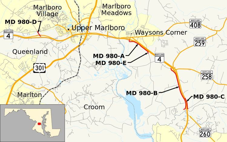
Maryland Route 980 (MD 980) is a designation used for a collection of five service roads in the U.S. state of Maryland along MD 4, four in Bristol and Waysons Corner in southern Anne Arundel County and one near Upper Marlboro in southern Prince George's County. MD 980 was assigned to the service roads constructed during the expansion of MD 4 to a four-lane divided highway in the early to mid-1960s.
Contents
Map of Maryland Route 980, Lothian, MD 20711, USA
Route description
The two longest segments of MD 980 are MD 980A and MD 980B, which have lengths of 1.07 miles (1.72 km) and 2.05 miles (3.30 km), respectively. MD 980A begins at an intersection with MD 980E (Plummer Lane) near Waysons Corner. The road heads northwest as MD 4 Service Road, a two-lane road parallel and adjacent to the southbound direction of MD 4. Midway through its run, the highway receives an exit ramp from southbound MD 4. MD 980A curves west and veers north to its terminus at a three-quarter diamond interchange with MD 4 (Stephanie Roper Highway) and MD 408 (Mount Zion–Marlboro Road), which curves east toward Waysons Corner.
MD 980B begins at a dead end at a gate just north of Lyons Creek. The road heads north as two-lane Southern Most Road, which passes close to the ramp from southbound MD 4 to eastbound MD 260 (Chesapeake Beach Road) and begins to parallel the southbound direction of MD 4 (Southern Maryland Boulevard). MD 980B's name changes to MD 4 Service Road at Lower Pindell Road, where an exit ramp from southbound MD 4 meets the service road. There is an entrance ramp to southbound MD 4 south of Upper Pindell Road. The highway closely parallels MD 4 until the latter highway's diamond interchange with MD 258 (Bay Front Road) in Bristol. MD 980B curves around the interchange and reaches its northern terminus at an intersection with Wrighton Road just west of Wrighton Road's intersection with the western end of MD 258 and an exit ramp from southbound MD 4.
There are three other segments of MD 980:
History
Southern Maryland Boulevard was constructed as a 18-foot-wide (5.5 m) concrete road from MD 4 at Waysons Corner—MD 4 then included what is now MD 408 east of Waysons Corner—to MD 2 at Sunderland in Calvert County between 1928 and 1930. The highway was designated MD 416 by 1933. The original highway followed the entire length of what is now MD 794 from Waysons Corner to Bristol. MD 416 continued south along what are now the northbound lanes of MD 4, then veered southwest and joined the course of MD 980B south of Lower Pindell Road. The highway crossed over Lyons Creek and under the Chesapeake Beach Railway at a location called Fishers Station. MD 416 was placed on MD 4's modern alignment at Lyons Creek between 1953 and 1956. The bypass left behind what is now part of MD 980B. MD 4 and MD 416 were expanded to a divided highway from the Patuxent River to south of Lyons Creek between 1959 and 1962. The northern part of MD 980B and MD 980A and MD 980C were built as the main highway's service roads by 1972. MD 980A began at a ramp from southbound MD 4. That highway was reconstructed in 1993 when MD 4 was reconstructed in Anne Arundel County and the MD 4–MD 408 interchange was built. MD 980D was constructed as the westernmost part of MD 4's freeway bypass of Upper Marlboro, which was built between 1959 and 1962. MD 980D was left behind when the MD 4 freeway was extended west beyond MD 223 in 1964.
MD 980A
The entire route is in Waysons Corner, Anne Arundel County.
MD 980B
The entire route is in Anne Arundel County.