
Existed: 1965 – present Constructed 1965 | Length 3.41 km | |
 | ||
Counties | ||
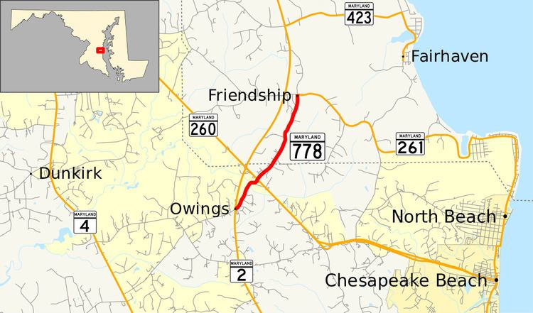
Maryland Route 778 (MD 778) is a state highway in the U.S. state of Maryland. Known as Old Solomons Island Road, the state highway runs 2.12 miles (3.41 km) from MD 2 near Owings north to MD 261 at Friendship. MD 778 and its unsigned auxiliary routes are segments of the old alignment of MD 2 in far northern Calvert County and southern Anne Arundel County. MD 2 was originally constructed as one of the original state roads in the early to mid-1910s. The state highway from Edgewater south to Owings was reconstructed in stages from the early 1950s to the mid-1960s, when the Owings–Friendship portion of MD 2 was relocated. As portions of the old MD 2 were bypassed, they were designated segments of MD 778.
Contents
Map of MD-778, Maryland, USA
Route description
MD 778 begins at an intersection with MD 2 (Solomons Island Road) south of Owings. The roadway continues on the other side of MD 2 as county-maintained Grovers Turn Road. MD 778 immediately intersects unmarked MD 765H, an unnamed old alignment of MD 2. The highway crosses over Hall Creek and meets MD 260 (Chesapeake Beach Road) in the village of Owings. Shortly after the intersection with MD 260, MD 778 crosses the Calvert–Anne Arundel county line. The state highway continues north through farmland to its northern terminus in the village of Friendship. From the northern terminus, MD 261 heads east as Friendship Road, a county-maintained portion of Friendship Road heads west toward MD 2, and Old Solomons Island Road continues north as a county highway toward a separate intersection with MD 2.
History
Solomons Island Road, including the portion of the highway from south of Owings to south of Edgewater, was chosen as one of the original state roads to be developed by the Maryland State Roads Commission in 1909. The highway from south of Owings to Lothian (also known as Mount Zion) was graded and surfaced as a dirt road between 1910 and 1912. That road was later surfaced with gravel and had many of the more dangerous curves modified by 1921. Solomons Island Road from Lothian to Edgewater was built as a 14-foot (4.3 m) wide gravel road in 1915. When state highways were first assigned numbers in 1927, Solomons Island Road became the southern part of MD 2. By 1934, MD 2 had been expanded to a width of 16 to 18 feet (4.9 to 5.5 m) south of Edgewater.
MD 2 from Owings to Edgewater starting receiving its first major upgrades in the 1950s, including several relocations of the highway. The bypassed portions of MD 2 became segments of MD 778, with the letter suffix on the highway designation corresponding to the order the sections were bypassed. The highway from Edgewater south to Harwood (then known as Butlers) was widened and resurfaced with bituminous stabilized gravel in 1950 and 1951. MD 2 from Harwood south to Lothian was widened and resurfaced with bituminous stabilized gravel in 1952 and 1953. Old Solomons Island Road between Harwood Road and Polling House Road in Harwood remained part of the state highway system until 1987.
Improvements to MD 2 from MD 423 north of Friendship to MD 258 north of Tracys Landing began in 1957 and were completed by 1960. That highway was first paved with bituminous stabilized gravel and later a second stage of bituminous concrete. The segment of Old Solomons Island Road immediately to the north of MD 423 remained in the state highway system until 1963. That same year, work on expanding and relocating the highway from Lothian south to MD 258 was completed. The portion of the old highway immediately to the south of Nutwell Road, now named Old Ridge Path Road, remained in the state highway system until 1987. MD 778 through Owings and Friendship was designated in 1965 when MD 2 was relocated to the west of the two villages. By 1999, the portion of MD 778 north of MD 261 was transferred to Anne Arundel County to be maintained.
Auxiliary routes
There are ten unsigned auxiliary routes of MD 778. These ten highways, all named Old Solomons Island Road, are old alignments of MD 2 between Friendship and Harwood in southern Anne Arundel County.