
Existed: 1927 – present Counties: Dorchester Constructed 1927 | Length 26.33 km | |
 | ||
Touristroutes: Harriet Tubman Underground Railroad Byway Chesapeake Country Scenic Byway South end: Hoopers Island Road on Hooper's Island | ||
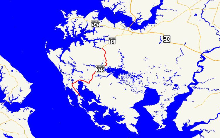
Maryland Route 335 (MD 335) is a state highway in the U.S. state of Maryland. The state highway runs 16.36 miles (26.33 km) from the upper end of Hooper's Island north to MD 16 in Church Creek. MD 335 provides access to several communities along the Honga River in southern Dorchester County. The state highway also passes through Blackwater National Wildlife Refuge. MD 335 was designated as one of the original state roads, but only the portion of the highway from Crossroads to the Blackwater River was completed by the early 1920s. The highway was constructed from Crossroads to Golden Hill in the mid-1920s, from Crossroads to Church Creek in the late 1920s, and from Golden Hill to Hooper's Island with the completion of a modern bridge over Fishing Creek in 1934.
Contents
Map of MD-335, Church Creek, MD 21622, USA
Route description
MD 335 begins in the village of Honga on Upper Hooper's Island just south of Applegarth Road. Hoopers Island Road continues south through Upper Hooper's Island and Middle Hooper's Island to the villages of Fishing Creek and Hoopersville. MD 335 heads north as Hoopers Island Road on a high-level bridge across Fishing Creek, a strait between Tar Bay and the Honga River. After heading north up Meekins Neck, the state highway curves to the east and enters the Great Marsh. Within the marsh, MD 335 intersects Smithville Road at the settlement of Golden Hill between crossings of Great Marsh Creek and Spicer Creek, which flow into the Honga River estuary. The state highway continues southeast where it crosses Wallace Creek before intersecting MD 336 (Lakesville Road) in the hamlet of Crossroads. MD 335 turns north onto Golden Hill Road and enters a series of swamps that make up Blackwater National Wildlife Refuge. After the state highway traverses the Blackwater River, the road passes by the Chesapeake Forest Lands and through farmland. MD 335 crosses Birch Dam Creek before entering the town of Church Creek. There, the highway reaches its northern terminus at MD 16, which is named Church Creek Road north toward Cambridge and Taylors Island Road headed west.
History
The road from Cambridge to Hooper's Island, which includes part of modern MD 16 and all of MD 335, was marked for improvement as one of the original state roads by the Maryland State Roads Commission in 1910. However, the first section of MD 335, from just north of the Blackwater River to 1 mile (1.6 km) south of Church Creek, was not improved until it was paved as a state-aid road by 1921. By 1923, pavement had been added from the southern end of the state-aid section south to Crossroads. The section from Crossroads to Golden Hill was completed in 1925. The section north of Blackwater River was reconstructed and extended to Church Creek by 1930. MD 335 south of Golden Hill was completed in 1933. The last piece of the state highway was a new bridge over Fishing Creek completed in 1934. The Fishing Creek Bridge was replaced in 1991 and 1992 contemporaneously with new bridges over the Blackwater River, Great Marsh Creek, and Spicer Creek.
Junction list
The entire route is in Dorchester County.