
Population 3,569 (2011) Civil parish Martham Area 11.84 km² | OS grid reference TG455185 Sovereign state United Kingdom Local time Monday 8:27 PM | |
 | ||
Weather 9°C, Wind SW at 10 km/h, 82% Humidity | ||
Roysia homes area tour of martham village nr29 norfolk
Martham is a village and civil parish in the English county of Norfolk and within the Broads National Park. It is situated some 15 km (9.3 mi) north-west of the town of Great Yarmouth and 30 km (19 mi) north-east of the city of Norwich.
Contents
- Roysia homes area tour of martham village nr29 norfolk
- Map of Martham Great Yarmouth UK
- Great yarmouth martham
- References
Map of Martham, Great Yarmouth, UK
The civil parish has an area of 11.84 km2 (4.57 sq mi) and in the 2001 census had a population of 3,126 in 1,267 households, the population including Cess and increasing at the 2011 Census to 3,569. For the purposes of local government, the parish falls within the district of Great Yarmouth. In recent years the population has expanded with considerable building of new housing. There is a good bus service to Great Yarmouth. There was formerly a station in the village adjacent to a level crossing on Rollesby Road Martham railway station, but this closed in 1959, when the entire line from Great Yarmouth to North Walsham was closed. The station buildings stood for another 30 years.
The villagers are well served with several shops including two small supermarkets, a butcher, Chinese take away, florist, pet supplies, bicycle repairs, and hairdresser. There are two public houses, The Victoria which hold an annual music festival called Vicfest, and The Kings Arms. Coastal Villages Practice has a comprehensive medical centre at the James Kittle Centre, Hemsby Road. There are four Churches meeting in the village, Church of England, Methodist, & Baptist congregations meet each week in their respective buildings. The New Wine Christian Fellowship meet in the Business Centre of Flegg High School.
Education is available in the village from Early Years to aged 16. Martham Primary & Nursery caters for children up to year 6, with Flegg High School taking students from year 7 to year 11. Post 16 education is available at other establishments outside of Martham.
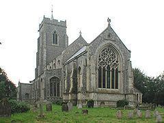
The village has several Georgian houses, a large village green, covering three areas of greensward and two duck ponds. Near St Mary's church Church of England, Ferrygate Lane leads to Martham Ferry, where an unusual floating swing bridge crosses the River Thurne. The bridge leads to Heigham Holmes, an island nature reserve, which can only be accessed by the public on special occasions. About 2 km (1.2 mi) to the north of the village is Martham Broad, a 140 acres (57 ha) nature reserve, which is not navigable by boat.
The Saxons settled in Martham around AD601 and gave the village its name, "the ham of the martens", the home of the polecats.
The Anglican missionary Anna Hinderer died in the village in 1870.