
Admin. region Arnsberg Time zone CET/CEST (UTC+1/+2) Population 20,993 (30 Jun 2010) Postal code 34431 | District Hochsauerland Area 182 km² Local time Monday 6:10 PM Administrative region Arnsberg | |
 | ||
Elevation 200 - 600 m (−1,800 ft) Weather 11°C, Wind NW at 10 km/h, 53% Humidity | ||
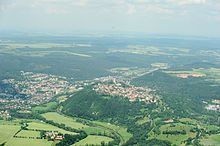
Marsberg is a town in the Hochsauerland district, in North Rhine-Westphalia, Germany.
Contents
- Map of 34431 Marsberg Germany
- History
- Geography
- Town division
- International relations
- Sons and daughters of the town
- References
Map of 34431 Marsberg, Germany
History
Although its origins are obscure, Marsberg was a prospering town by the 13th century (it was even minting coins). It was a free city until 1807, when it was incorporated into the Kingdom of Westphalia, until 1813. After two years of freedom, it was included into Prussia in 1815.
Geography
It is situated on the river Diemel, approx. 20 km east of Brilon and 30 km south of Paderborn.
Town division
Marsberg consists of the following 17 districts:
International relations
Marsberg is twinned with:
Sons and daughters of the town
References
Marsberg Wikipedia(Text) CC BY-SA