
Intercommunality Ouest Guyanais INSEE/Postal code 97353 / 97370 Local time Monday 1:34 AM | Population (2012) 9,970 Area 18,360 km² Number of airports 1 | |
 | ||
Weather 23°C, Wind NE at 6 km/h, 95% Humidity Arrondissement | ||
Bush flying amazon maripasoula to saul x plane 10
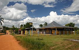
Maripasoula is a commune of French Guiana, an overseas region and department of France located in South America. With a land area of 18,360 km2 (7,090 sq mi), Maripasoula is the largest commune of France, and is recognized as the fourteenth largest city in the world by surface area.
Contents
- Bush flying amazon maripasoula to saul x plane 10
- Map of Maripasoula French Guiana
- Flamb e des prix maripasoula
- Geography
- Administration
- Demographics
- National park
- Protected buildings and historical monuments
- Notable residents
- References
Map of Maripasoula, French Guiana
Flamb e des prix maripasoula
Geography
Geographic Information of Maripasoula:
The surrounding of the town are
Administration
Maripasoula City is the capital of the county.
Mayor of Maripasoula is called sir Robert Balla. For all your administrative tasks, you can go to City Hall Avenue Leonard Domerger.
The municipality is part of the Ouest Guyanais community of communes.
Demographics
Its inhabitants are known in French as Maripasouliens and Maripasouliennes.
The town has 4,538 inhabitants from the last population census from 2004. With a density of 0.2 inhabitants per km², Maripasoula was a sharp increase of 24.3% of its population by 1999.
Old name of the town was Upper Maroni (1953).
National park
Maripasoula territory belongs to the Guiana Amazonian Park (French: Parc amazonien de Guyane).
Protected buildings and historical monuments
Petroglyphs of the Maroni river (archaeological site, ornate rock): engraved rocks, including their field of plate. Roche main site identified in 1948.
Shelter and painted shelters with archaeological remains of the Inselberg Susky (Archaeological site, rock shelter): the face is the Inselberg Susky including different projections with Shelters A (archaeological layer), B (buffers and potsherds) and F (rock paintings).
The wall of the shelter of the F Inselberg Suski includes 136 paintings dating probably AD e (...) Features: polisher
Notable residents
Cyrille Regis (9 February 1958), a former West Bromwich Albion, Coventry City, and England national football team player, was born in Maripasoula.