
Population 241 (2011 census) Postcode(s) 5575 Founded 1872 Local time Monday 2:20 PM | Established 1872 State electorate(s) Goyder Postal code 5575 | |
 | ||
Weather 23°C, Wind S at 21 km/h, 57% Humidity | ||
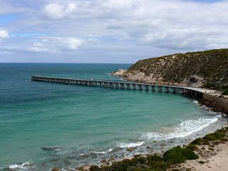
Marion Bay is a small township in the Australian state of South Australia at the southern tip of the Yorke Peninsula. At the 2011 census, Marion Bay had a population of 241.
Contents
Map of Marion Bay SA 5575, Australia
Description
It is surrounded by beaches and is the gateway to the Innes National Park. The close proximity of the beach and cliffs have popularized Marion Bay as a fishing destination, with Brown Beach in the nearby Innes National Park being particularly famous among recreational fisherman as a picturesque fishing destination.
Water supply
In 2008, a desalination plant was commissioned to meet the water demands of the summer tourist season. A 60 kL/d sea water reverse osmosis plant now supplies the local caravan park, residents and businesses. The plant was commissioned in response to declining bore water quality and associated problems of corrosion. The plant was designed and constructed by Osmoflo.
Governance
Marion Bay is located within the federal Division of Grey, the state electoral district of Goyder and the local government area known as the Yorke Peninsula Council.