
 | ||
Similar Blyde River, Blyderivierpoort Dam, Blyde River Canyon, Bourke's Luck Potholes, Blyde River Canyon Nature R | ||
Video from mariepskop drakensberg
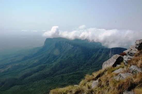
Mariepskop (or Marepe), at 1,945 m above sea level, is one of the highest peaks in the northern Drakensberg, and the highest point of the Blyde River Canyon, South Africa. It is situated at the junction of three conservation areas, namely the Mariepskop Forest Reserve, Mariepskop State Forest, and the Blyde River Canyon Nature Reserve. The mountain is bordered by sheer cliff faces on several sides, and is composed of Proterozoic sedimentary rocks of the Transvaal Supergroup. It is named for the 19th century Pulana chief, Maripe Mashile, whose tribe used the mountain as a stronghold. Some infrastructure and roads were built in the 1950s to service a military radar station. Mariepskop is flanked by Tshwateng (1,628 m) at the opposite side of the Blyde River, and by Hebronberg (1,767 m) in the south.
Contents
Map of Mariepskop, South Africa
Geology
The mountain is composed of Proterozoic sedimentary rocks, namely quartzite, shale and dolomite of the Transvaal Supergroup. The plateau consists of resistant Black Reef Quartzite which rests on quartzite and shale of the Wolkberg Group, with a granite-gneiss layer forming the base.
History
The Mfecane disturbances of the 19th century was responsible for the settlement of the escarpment region by fragments of Sotho-speaking tribes, who once lived on the highveld. Bakwena chief Kowyn settled on the Graskop escarpment, and the Mapanjams settled in wretched circumstances in the lowveld. Everywhere south of the Olifants River, these refugees were harried and looted by Swazi raiding parties. Chief Maripe's tribe settled at the base of "the great one", or Thaba ya Moholoholo, as the mountain was then known.
To evade their common enemy, chief Maripe and Tshilwane's Pulana, and Mohlahla's Pedi people, sought refuge on the mountain plateau. In the Moholoholo war of 1864, boulders were rolled down to ward off the enemy, and the attacks on their stronghold were repelled. Skeletons of the Swazi casualties littered the mountain for a long time afterwards. Quite a number of local place names commemorate this tumultuous period. The nearby Three Rondavel peaks are named for three of the chief's wives, Magabolle, Mogoladikwe and Maseroto, while the adjacent Mapjaneng promontory, once again recalls the chief. Swadeni (also Swadini or Swatini), meaning "the place of the Swazi" seems to be the only place name to commemorate the Swazis, who attacked but never occupied the region for an extended period.