
Established 1880 Area code 013 | Elevation 1,436 m (4,711 ft) Local time Saturday 5:55 PM | |
 | ||
Weather 21°C, Wind E at 8 km/h, 64% Humidity Points of interest Blyde River Canyon Nature R, Mac‑Mac Falls, Berlin Falls, Lone Creek Falls | ||
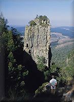
Graskop is a small town in Mpumalanga province, South Africa. It was set up in the 1880s as a gold mining camp but it now serves as a tourist destination and the timber industry. The name is Afrikaans for grassy peak. “God’s Window”, a scenic view from the escarpment of the Lowveld below, is located outside the town.
Contents
Map of Graskop, 1270, South Africa
Town 14 km south-east of Pilgrim's Rest and 28 km north of Sabie. It was laid out between 1880 and 1890 on a farm belonging to Abel Erasmus, Native Commissioner of the Transvaal Republic. Named after a grassy hillock (Afrikaans gras, ‘grass’, kop, ‘hillock’). Originally it was a mining camp. It is the best place to view the "Edge of the Lowveld", with a sudden drop of 700 metres.
Lisbon falls graskop south africa
References
Graskop Wikipedia(Text) CC BY-SA