
Airport type Public Elevation AMSL 110 ft / 34 m 8/26 4,895 Phone +1 850-482-2281 | Website cityofmarianna.com/... Elevation 34 m | |
 | ||
Owner Marianna Municipal Airport Authority Address 3689 Industrial Park Dr, Marianna, FL 32446, USA Similar Jackson County Floridan, Marianna High School, Riverside Elementary School, Hatcher Publishing - Inc, Marianna Planning & Develop | ||
C 17 cargo plane taking off at marianna municipal airport in marianna fl
Marianna Municipal Airport (ICAO: KMAI, FAA LID: MAI) is a public airport five miles northeast of Marianna, in Jackson County, Florida. It is owned by the Marianna Municipal Airport Authority. The FAA's National Plan of Integrated Airport Systems for 2009–2013 categorized it as a general aviation airport. It was formerly Graham Air Base.
Contents
- C 17 cargo plane taking off at marianna municipal airport in marianna fl
- Civil use
- Facilities
- References
Many U.S. airports use the same three-letter location identifier for the FAA and IATA, but this airport is MAI to the FAA and has no IATA code. (IATA assigned MAI to Mangochi, Malawi).
Civil use
National Airlines (NA) initially provided commercial air service to the airport utilizing Convair 340/440 series aircraft. The airline discontinued service in 1961 and the airport has had few or no airline flights since.
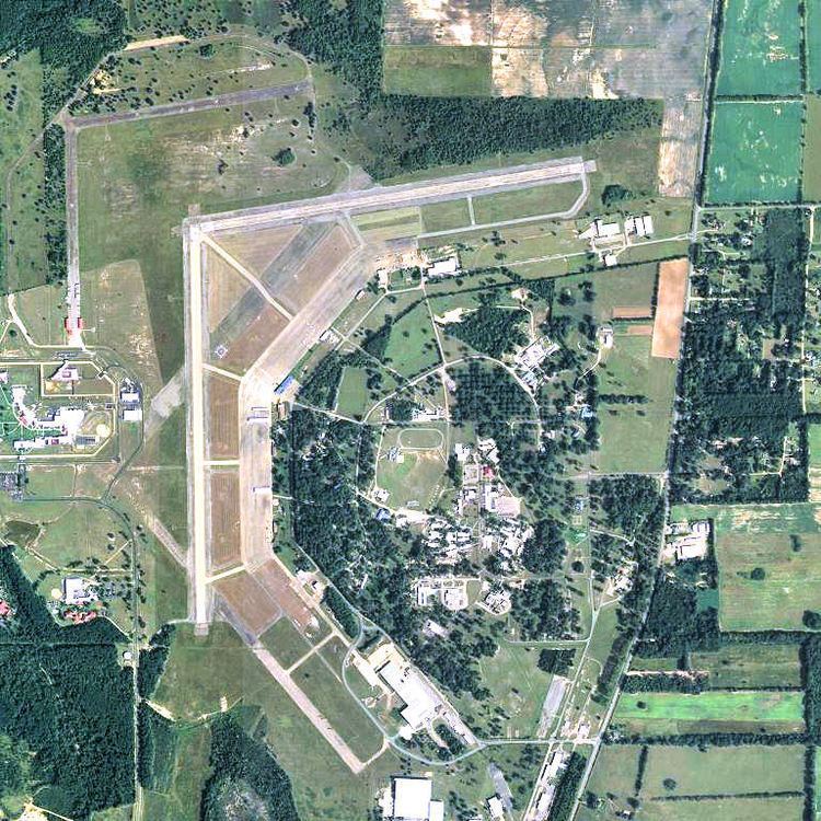
The airport has two 4,900-foot (1,500 m) by 100-foot (30 m) intersecting hard surface runways with a pavement strength of 56,500 pounds single wheel load. Runway 18/36 is the primary runway. Although the USAF control tower and base operations building remain on the flight line, the airport has been an uncontrolled field for its entire time as a civil airport.
The airport continues to see military aircraft, with a third of the airport's operations normally being transient military training flights, mostly Army helicopters from Fort Rucker and Navy helicopters from Naval Air Station Whiting Field.
Facilities
The airport covers 2,400 acres (970 ha) at an elevation of 110 feet (34 m). It has two operational asphalt runways: Rwy 8/26 is 4,895 by 100 feet (1,492 x 30 m) and Rwy 18/36 is 4,896 by 100 feet (1,492 x 30 m).
In the year ending March 9, 2009 the airport had 28,016 aircraft operations, average 76 per day: 67% general aviation and 33% military. 30 aircraft were then based at the airport: 66.7% single-engine, 20% multi-engine, 6.7% helicopter and 6.7% glider.