
Location Pacific Ocean Length 5.6 km (3.48 mi) Area 7 km² | Width 2.9 km (1.8 mi) Administrative subdivision Tuamotus Island group Tuamotus | |
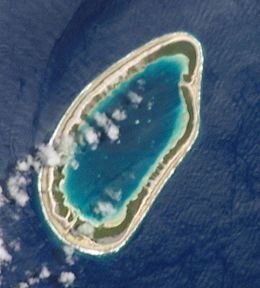 | ||
Maria Atoll is an uninhabited small atoll of the Tuamotu group in French Polynesia. It is located in the far southeast of the archipelago, about 72 km (45 mi) southwest from Marutea Sud. Maria's closest neighbour is the small atoll of Matureivavao of the Acteon Group, 56 km (35 mi) to the northwest.
Contents
Map of Maria
Maria Atoll is oval in shape and bound by a continuous reef. It is 5.6 km long and 2.9 km wide. Its islands are low and flat and the lagoon is hypersaline.
This atoll is mostly called "Maria Est" in order to avoid confusion with another small atoll called Maria (Nororotu) in the Tubuai (Austral Islands) division of French Polynesia.
History
The first recorded European who arrived to Maria Est was Jacques-Antoine Moerenhout in 1829. In some maps, Maria Atoll appeared as "Moerenhout Island". In 1850, it was inhabited by about 40 indigenous people.
Administration
Administratively, Maria Est belongs to the commune of the Gambier Islands.