
Country United States FIPS code 29-45830 Elevation 154 m Population 7,968 (2013) | Time zone Central (CST) (UTC-6) GNIS feature ID 0756345 Area 4.04 km² Local time Monday 1:40 PM | |
 | ||
Weather 27°C, Wind W at 11 km/h, 41% Humidity Points of interest Deer Creek Park, Ryan Hummert Memorial, Escape from St Louis, THE JCO, Escape STL | ||
Maplewood is an inner-ring suburb of St. Louis, located in St. Louis County. The population was 8,046 at the 2010 census.
Contents
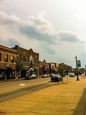
- Map of Maplewood MO USA
- Geography
- History
- 2010 census
- 2000 census
- Public School District
- Notable people
- References
Map of Maplewood, MO, USA
Geography
Maplewood is located at 38°36′45″N 90°19′17″W (38.612535, -90.321339).
According to the United States Census Bureau, the city has a total area of 1.56 square miles (4.04 km2), all of it land.
History
Maplewood was established around the turn of the 20th century. Maplewood was one of the early suburbs of St. Louis. Located just outside the city limits, Maplewood was located at the end of one of St. Louis's streetcar lines and was also located near major railroads.
It was built as a bedroom community. Advertising suggested that people should get away from the city (in an era of common and sooty commercial, industrial, and domestic coal burning) and enjoy the fresh air of less densely populated areas like Maplewood. Maplewood's historic residential areas were mostly built from 1900–1910 and a number of well-preserved homes remain. Several of these homes have remained in the same family for generations.
Maplewood is currently being revitalized by an influx of restaurants, businesses, and shops around Manchester Ave., Sutton Ave., and the Greenwood Historic District.
2010 census
As of the census of 2010, there were 8,046 people, 4,269 households, and 1,769 families residing in the city. The population density was 5,963.8 people per square mile (2,298.7/km²). There were 4,889 housing units at an average density of 3,403.3 per square mile (1,311.8/km²). The racial makeup of the city was 74.1% White, 17.2% African American, 0.2% Native American, 3.5% Asian, 0.1% Pacific Islander, 1.3% from other races, and 3.5% from two or more races. Hispanic or Latino of any race were 2.22% of the population.
There were 4,269 households of which 18.6% had children under the age of 18 living with them, 25.3% were married couples living together, 12.2% had a female householder with no husband present, and 58.6% were non-families. 48.6% of all households were made up of individuals and 6.5% had someone living alone who was 65 years of age or older. The average household size was 1.88 and the average family size was 2.78.
In the city, the population was spread out with 19.1% under the age of 20, 9.1% from 20 to 24, 37.0% from 25 to 44, 26.9% from 45 to 64, and 7.9% who were 65 years of age or older. The median age was 34.7 years. The city was 50.2% male and 49.8% female.
2000 census
As of the census of 2000, there were 9,228 people, 4,815 households, and 2,041 families residing in the city. The population density was 5,963.8 people per square mile (2,298.7/km²). There were 5,266 housing units at an average density of 3,403.3 per square mile (1,311.8/km²). The racial makeup of the city was 76.16% White, 15.93% African American, 0.33% Native American, 4.23% Asian, 0.07% Pacific Islander, 0.72% from other races, and 2.58% from two or more races. Hispanic or Latino of any race were 2.22% of the population.
There were 4,815 households out of which 19.1% had children under the age of 18 living with them, 27.1% were married couples living together, 81.6% had a female householder with no husband present, and 5.6% were non-families. 4.5% of all households were made up of individuals and 7.5% had someone living alone who was 65 years of age or older. The average household size was 1.92 and the average family size was 2.83.
In the city, the population was spread out with 18.3% under the age of 18, 13.0% from 18 to 24, 39.0% from 25 to 44, 20.6% from 45 to 64, and 9.1% who were 65 years of age or older. The median age was 34 years. For every 100 females there were 99.6 males. For every 100 females age 18 and over, there were 98.7 males.
In 2000 the median income for a household in the city was $29,151, and the median income for a family was $44,178. Males had a median income of $30,279 versus $24,025 for females. The per capita income for the city was $19,087. About 10.6% of families and 14.1% of the population were below the poverty line, including 17.5% of those under age 18 and 9.1% of those age 65 or over.
Public School District
The Maplewood Richmond Heights High School, tracing its beginnings to 1840, is part of the oldest school district in St. Louis County. The district covers an approximate area of two square miles and is located southwest of, and adjacent to, the city of St. Louis. Neighboring school districts include Brentwood, Clayton, and Webster Groves.