
County El Paso Time zone MST (UTC-7) Elevation 1,938 m | Incorporated January 25, 1888 Area code(s) 719 Zip code 80829 | |
 | ||
Weather 15°C, Wind W at 16 km/h, 14% Humidity Points of interest Manitou and Pike's Peak Rail, Manitou Cliff Dwellings, Manitou Incline, Miramont Castle, Arcade Amusements Inc | ||
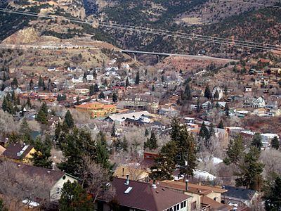
The city of Manitou Springs is a home rule municipality located in El Paso County, Colorado, United States. The town was founded for its scenic setting and natural mineral springs. The downtown area continues to be of interest to travelers, particularly in the summer, as the downtown area consists of many one-story, adjoining, small shops, restaurants, and pubs, as well as a creekside city park with a children's playground made from unusual materials. Among other services, shops cater to tourist interests such as clothing, candy, souvenirs, and outdoor recreation. The main road through the center of town was one of the direct paths to the base of Pikes Peak. Barr Trail, which winds its way up Pikes Peak, is easily accessible from town. The subdivision Crystal Hills was added to the municipality in the 1960s.
Contents
- Map of Manitou Springs CO 80829 USA
- History
- Springs compromised in the 1970s
- Historic district
- Waldo Canyon fire
- Waldo Canyon flash flood
- Government
- City council
- City boards and commissions
- Geography
- Demographics
- Attractions
- Mineral springs and parks
- Events
- Inns and hotels
- Notable people
- References
Map of Manitou Springs, CO 80829, USA
The city population was 4,992 at the 2010 United States Census. Students are served by Manitou Springs School District 14 and Manitou Springs High School.
History
General William Jackson Palmer and Dr. William Abraham Bell founded Manitou Springs in 1872, intending the town to be a "scenic health resort". Dr Bell's home, Briarhurst Manor, is open to the public as a fine dining restaurant, which is listed on the National Register of Historic places. In 1876, the town was incorporated. "Manitou Springs has been the quintessential tourist town since the 1870s, when visitors discovered the healing waters the Ute Indians had been drinking for years. Many of the town's mineral springs still function today and the water is free."
Springs compromised in the 1970s
In the 1970s, Woodland Park, 19 miles (31 km) up Ute Pass, built a sewage treatment plant on top of the fault line that forms the pass. As a result, many of the springs were made undrinkable during the bulk of the 1980s, but this has since largely been corrected.
Historic district
In 1980, the Manitou Springs Historic District was formed by the Historic Preservation Committee to manage development, renovation and preservation within the town. It is National Register of Historic Places listing and one of the country's largest National Historic Districts.
Waldo Canyon fire
In June 2012, the entire city was evacuated due to the Waldo Canyon fire burning nearby. Portions of western Colorado Springs were also evacuated. Manitou Springs did not suffer any fire damage, and the city was under evacuation orders from only 1:30 a.m. Monday until 8 p.m. the same day, when the order was lifted and residents were allowed back home. There was no fire damage visible from Manitou Springs, and all businesses were reopened.
Waldo Canyon flash flood
On the afternoon of August 9, 2013, the city was inundated by a flash flood entering the northern edges of the city via roadways and natural channels as it descended from the flooded out US Hwy 24. Traffic was stopped in both directions as the highway barriers formed a river drifting several occupied cars down a runoff ditch. The strong current made a path down Manitou Avenue from Cavern Gulch as well as Canon Avenue meandering turbulently through streets, homes, businesses, and spillways damaging 20 homes, 8 of them significantly. The flood water threatened buildings and parking lots situated along Fountain Creek and closed a portion of Manitou Avenue which re-opened later that evening.
Government
Manitou Springs is a local government and a home rule city located within the Colorado Springs metropolitan area.
City council
Manitou Springs is managed by the elected mayor and six city council members. The mayor is elected to a two-year term. Council members are elected to 4 year, overlapping, terms. Three council members are "at large" members and three members represent one of the 3 wards in Manitou Springs. Manitou Springs residents may attend the following meetings or working sessions held each month at the Council Chambers at 606 Manitou Avenue.
City boards and commissions
The Manitou Springs City Boards and Commissions include:
Geography
Situated directly along U.S. Route 24 just west of Old Colorado City and Cave of the Winds, the town is bordered by Mt. Manitou to the west, Red Mountain to the south, and Englemann Canyon, south and west. It is near Garden of the Gods, with the same red stone as Red Mountain, and is at the base of Pikes Peak. According to the United States Census Bureau, the city has a total area of 3.2 square miles (8.2 km2), all of it land.
Demographics
As of the census of 2000, there were 4,980 people, 2,452 households, and 1,255 families residing in the city. The population density was 1,642.6 people per square mile (634.6/km²). There were 2,654 housing units at an average density of 875.4 per square mile (338.2/km²). The racial makeup of the city was 93.98% White, 3.65% Hispanic or Latino, 0.50% African American, 1.06% Native American, 1.12% Asian, 0.12% Pacific Islander, 0.94% from other races, and 2.27% from two or more races.
There were 2,452 households out of which 22.0% had children under the age of 18 living with them, 40.2% were married couples living together, 8.2% had a female householder with no husband present, and 48.8% were non-families. 38.2% of all households were made up of individuals and 7.3% had someone living alone who was 65 years of age or older. The average household size was 2.03 and the average family size was 2.73.
In the city, the population was spread out with 18.6% under the age of 18, 7.2% from 18 to 24, 31.6% from 25 to 44, 32.2% from 45 to 64, and 10.3% who were 65 years of age or older. The median age was 41 years. For every 100 females there were 94.9 males. For every 100 females age 18 and over, there were 92.5 males.
The median income for a household in the city was $40,514, and the median income for a family was $57,260. Males had a median income of $39,102 versus $24,286 for females. The per capita income for the city was $24,492. About 4.7% of families and 7.9% of the population were below the poverty line, including 4.3% of those under age 18 and 10.1% of those age 65 or over.
Attractions
Attractions include:
Mineral springs and parks
Events
Annual Events include:
Inns and hotels
Notable people
Current resident of the city, the most successful male athlete in the history of the Pikes Peak Marathon is Matt Carpenter, the outright record holder and winner of the marathon on eleven occasions.