
Trailheads Barr Trail Trailhead Barr Trail | Use Hiking | |
 | ||
Length Approx. .88 miles (1.42 km) Highest point Peak, 8,590 feet (2,620 m) Lowest point Base, 6,500 feet (2,000 m) Similar Barr Trail, Pikes Peak, Manitou and Pike's Peak Rail, Manitou Cliff Dwellings, Garden of the Gods Visitor | ||
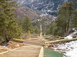
The Manitou Springs Incline, also known as the Manitou Incline or simply the Incline, is a popular hiking trail rising above Manitou Springs, Colorado, near Colorado Springs. The trail is the remains of a former 3 ft (914 mm) narrow gauge funicular railway whose tracks washed out during a rock slide in 1990. The Incline is famous for its sweeping views and steep grade, with an average grade of 45% (24°) and as steep as 68% (34°) in places, making it a fitness challenge for locals in the Colorado Springs area. The incline gains over 2,000 feet (610 m) of elevation in less than one miFriendsle.
Contents
- Map of The Incline Cascade CO 80809 USA
- History
- Legal battles
- Hiking trail and fitness challenge
- Records
- References
Map of The Incline, Cascade, CO 80809, USA
History
The Incline was constructed under the ownership of Dr. Newton N. Brumback (1854-1923) as a funicular in 1907, for the purpose of providing access to water tanks at the top of the mountain that would provide gravity-fed water pressure to the cities of Manitou Springs and Colorado Springs. Originally, the railroad was constructed to access the hydroelectric plant and service the water pipes, but shortly after its construction, the railway was opened as a tourist attraction. The Incline's original summit house was a rudimentary building constructed from left over materials from the Incline's construction, and burned down in 1914. The summit house was quickly rebuilt into a more elaborate, comfortable, and safer structure, offering shelter from storms and the elements. The 1914 structure remained until replaced by an updated summit house in 1958, which remained until it was dismantled after the Incline's closure. The Incline operated under the Pikes Peak Cog Railway until a rock slide in 1990 washed out the rail bed and the Cog Railway decided to not repair the tracks.
Legal battles
Though the Incline is a popular hike and fitness destination for locals, its existence since its public closing in 1990 has been controversial. Many locals and some National Forest Service officials wanted to keep it closed to allow it to revegetate, either by reseeding or allowing nature to reclaim the scar. But the real controversy centered over parking rights at the base of the trail head, which is co-located with the Barr Trail trail head and the Pikes Peak Cog Railway. All three sit in the narrow Ruxton Canyon, and the popularity of the Incline has caused major parking conflicts with these entities. The land through which the Incline passes on its ascent is owned by three entities: the bottom portion is owned by the City of Colorado Springs, the middle section is owned by the Pikes Peak Cog Railway and the top portion is owned by the US Forest Service. The legal battles over the conversion of the Incline to a public hiking trail were finally resolved in January 2013, and the wranglings even went all the way to the United States Congress.
Hiking trail and fitness challenge
Since its closure as a railway in 1990, the trail has steadily grown in popularity as a hiking trail and fitness challenge. The base of the Incline sits at 6,600 feet (2,000 m) and the trail climbs 2,000 feet (610 m) in about 0.88 miles (1.42 km). Sections of the trail have exposed pipe from the days when the Incline was a hydroelectric utility system. Hiking the trail should not be undertaken by the physically unfit, as there is no vehicle access to the trail and anyone injured or suffering a medical emergency will have to walk or be carried down by other hikers. At the top of the Incline, there is a tie-in to the Barr Trail that allows for hikers to descend without going back down the Incline. (This descent is approximately 4 miles with a much gentler slope.)Due to the close proximity to the large and active population center of Colorado Springs, the large military population of nearby Army and Air Force bases, and the US Olympic Training Center, the Incline has become a wildly popular fitness destination for those craving an intense cardio workout.
About 2/3 of the way up, a Barr Trail switchback passes just a few yards from the Incline, and there is a pathway that allows those who wish to exit the Incline the opportunity to take the Barr Trail back down. Locals refer to this point as the 'Bailout' or the 'Wimpout' point. The Incline is at its steepest grade just after the bailout for about another 200 feet (61 m), when it reaches the 'false summit', a semi-crest in the trail that obscures the true summit to hikers due to its extreme grade. Those who reach the false summit are about 3/4 of the way to the top, but still have several hundred feet to climb. When standing at the summit of the Incline, you will be looking East-Northeast towards Colorado Springs. If you travel south down the hill, you will pick up a trail that links into the Barr trail, a much less steep path down the mountain and the preferred descent route during busy trail hours.
Records
The verifiable satellite tracked record was set September 25, 2015, of (17:45) by US mountain running team member Joseph Gray. Other notable times belong to local running legend and twelve time champion of the Pikes Peak Marathon, Matt Carpenter (18:31). The female Incline record is attributed to Allie McLaughlin of Colorado Springs (20:07). In 2012, Brandon Stapanowich set the first speed record for an 'Inclinathon', which is 13 laps of the Incline (about 26 miles). His time: 11 hours 46 minutes. In 2014, Stapanowich also completed the first ever Ultra-Inclination, completing 22 laps of the Incline in 24 hours, the most ever completed in a day. He gained 44,000 ft in this endeavor. On May 16, 2015, Wade Gardner reset the record for the Inclinathon. His time: 10 hours 34 mins.
In 2011, local resident and type-I diabetic, Greg Cummings, became the first person to hike the Incline more than 500 times in one year. Along with 34 ascents of Pikes Peak, Cummings ascended the Incline 601 times. In 2013, local resident, Roger Austin, ascended the Incline 719 times and reset the World Record to roughly 1.43 million vertical feet hiked/climbed in one year. In 2014, Greg Cummings, ascended the Incline 1,400 times in 330 consecutive days, before the Incline closed for repairs. Along with other ascents, Cummings reset the World Record for vertical feet hiked/climbed in one year to just over 2.9 million. In 2015, Roger Austin, ascended the Incline 1,719 times and reset the World Record for vertical feet ascended in one year to just over 3.4 million. Along the way, Austin set the record for most Inclinathons in one year. His record: 26.
In 2012, local resident and Incline legend Ed Baxter, 58, became the first known person to complete the 'Inclinathon', 13 consecutive trips up and down the Incline, taking him just over 13 hours.
There is a club called The Incline 500 Club. To become a member, a person must ascend the Incline a minimum of 500 times in 365 consecutive days. As of August 2016, there are eight members.
The Incline has a Facebook page and an Outdoor Colorado section of the Colorado Springs Gazette where locals post photos and records.