
Basin size 1,461 sq mi (3,780 km) Source Alger County, Michigan | Length 114 km | |
 | ||
Bridges Ten Curves Road-Manistique River Bridge | ||
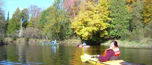
Kayaking in seney national wildlife refuge on the manistique river
The Manistique River is a 71.2-mile-long (114.6 km) river in the U.S. state of Michigan that winds southward through the central Upper Peninsula from its headwaters near Lake Superior to its mouth in Lake Michigan. It drains approximately 1,461 square miles (3,780 km2) of the Upper Peninsula, including most of Schoolcraft County and small portions of Alger County, Delta County, Luce County, and Mackinac County. The river rises at the outlet of Manistique Lake in the southwest corner of Luce County, and after flowing through the Seney National Wildlife Refuge, empties into Lake Michigan at Manistique, Michigan. M-77, a north-south highway, serves much of the Manistique River's drainage and crosses the river and its tributaries several times.
Contents
- Kayaking in seney national wildlife refuge on the manistique river
- Map of Manistique River Manistique MI USA
- Boreal forest wetlandsEdit
- LakesEdit
- RecreationEdit
- Current eventsEdit
- References
Map of Manistique River, Manistique, MI, USA
Boreal forest wetlandsEdit
The drainage of the Manistique River is very flat and sandy. The river is not characterized by rapids or waterfalls. Instead, it wriggles along an alluvial bed of sand and silt eroded and redeposited by the river itself. The Manistique River's drainage was one of the last zones in Michigan to be clear cut, with old-growth timber being felled as late as the 1910s. The watershed was then abandoned or reverted to state and federal ownership. As of 2007, 93% of the drainage was forested, largely with second-growth trees such as aspen and birch. More than one-half, 58%, of the drainage was owned by the federal government or the state of Michigan. Governmental ownership units included the Seney National Wildlife Refuge, Hiawatha National Forest, and Lake Superior State Forest.
LakesEdit
Major lakes drained by the Manistique River include Indian Lake north of Manistique, Manistique Lake in the central Upper Peninsula, and two tributary lakes, North Manistique Lake and South Manistique Lake. The lakes have several motorboat ramps.
RecreationEdit
Because the Manistique River is relatively slow and flat through much of its length, it is a favorite for novice-to-intermediate-level canoeists and kayakers. Fishing for bass, pike, and walleye is popular. A small population of trout challenges anglers.
Current eventsEdit
The Manistique River is classified as a Great Lakes Area of Concern (AOC).