
Elevation 1,885 m | Age of rock unknown Last eruption Unknown | |
 | ||
Similar Silay, Mahagnao Volcano, Mount Talinis, Mount Makaturing, Latukan | ||
The Mandalagan volcano is located at latitude 10.65° North (10°39'0"N), longitude 123.25° East (123°15'0"E), in the province of Negros Occidental, on the north of the island of Negros of the Philippines.
Contents
Map of Mandalagan, Philippines
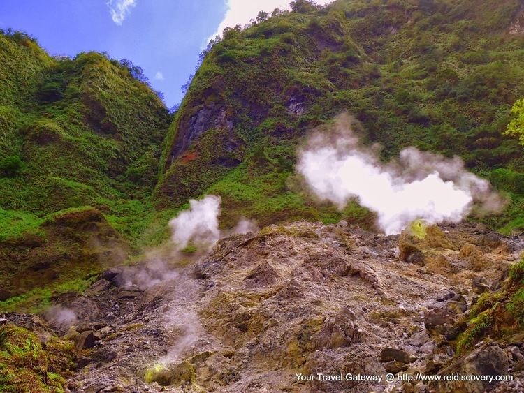
Mandalagan is a solfataric, fumarolic, potentially active stratovolcano.
Physical Features
Elevation is 1885 metres (6,184 feet), with a base diameter of 26 kilometres.
Mandalagan is a deeply dissected complex volcano, with a highly altered volcanic dome.
Volcanic activity is reported to include seven volcanic centres, at least five craters and/or calderas up to 2 klms in diameter, and a vigorous solfataric area at the highly altered volcanic dome structure.
One solfataric area emits a high-temperature (106 degrees C) plume to 30 m height with a roaring noise like a high-pressure geothermal borehole.
Images
The Smithsonian listing has a satellite photograph of the general area.
Geological Features
Mandalagan is part of the Negros Volcanic Belt.
Rock type is principally andesitic with some dacitic
A Crater located near the center called "Tinagong Dagat", where hiking tourists stay
Eruption
The most recent eruption produced a thin basaltic lava flow, but it is not known when this is likely to have occurred.
Listings
Philippine Institute of Volcanology and Seismology (PHIVOLCS) lists Mandalagan as potentially active.
The Smithsonian Global Volcanism Program lists Mandalagan as fumarolic.