
Population 2,449 (2001 census) Civil parish Mancetter Local time Sunday 8:01 PM | OS grid reference SP3296 Sovereign state United Kingdom Dialling code 01827 | |
 | ||
Weather 12°C, Wind SW at 18 km/h, 83% Humidity | ||
Mancetter is a village and civil parish on the southeastern outskirts of Atherstone in North Warwickshire, at the crossing of Watling Street over the River Anker. The population (including Gopsall, Leicestershire) had reduced from 2,447 to 2,339 at the 2011 census.
Contents
Map of Mancetter, Atherstone, UK
History
During the Roman occupation of Britain a posting station was built athwart Watling Street close to the river crossing, and a rectangular earthwork of this station is still extant. Around the station grew the settlement of Manduessedum. It is thought that Mancetter is the most likely location of the Battle of Watling Street, between an alliance of indigenous British peoples led by Boudica and a Roman army led by Gaius Suetonius Paulinus, although the exact location is unknown.
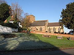
Mancetter does not appear in the Domesday Book of 1086 but in 1196 a Walter de Mancetter granted land to endow the parish church. The chancel walls of the Church of England parish church of Saint Peter still include 12th century masonry. The chancel and nave were remodelled early in the 13th century and the north aisle was added later in the 13th century. The bell tower, the south aisle and the clerestorey of the nave all seem to have been added in the 15th century. The south porch was added early in the 17th century. Restoration work was carried out in 1876, 1911 and 1930, and the Gothic Revival architect C.C. Rolfe may have undertaken restoration work in 1899. The tower has a peal of five bells, of which the oldest was cast about 1350, another early in the 16th century and the treble, tenor and third bell in the middle of the 17th century.
The advowson of St. Peter's was impropriated by the Cistercian Abbey of Merevale in 1449.
Mancetter Manor House is a timber-framed building dating from about 1330. An intermediate floor was inserted in the great hall in about 1480 and the south wing was added in about 1580. The central chinmeystack was probably inserted in the 17th century and small extensions to the house were made in the 18th and 19th centuries.
Etymology
The modern name Mancetter is a reduced form of an old Celtic name Manduessedum, first recorded in the Antonine Itinerary in the 4th Century. It is composed of a British element *mandu – ‘horse’ or ‘pony’ and a Gaulish *essedo - ‘horse chariot’. Although the first element is common in Gaulish names, the application of the second element to a place-name is obscure. The second element of the modern name is the OE ceastre – ‘a city, an old fortification, Roman site’.