
- location Pacific | Length 670 km | |
 | ||
- average 4,580 m/s (161,740 cu ft/s) | ||
The Mamberamo is a large river on the island of New Guinea, in the Indonesian province of Papua. It is the largest river in Indonesia by volume of discharge, and also the widest.
Contents
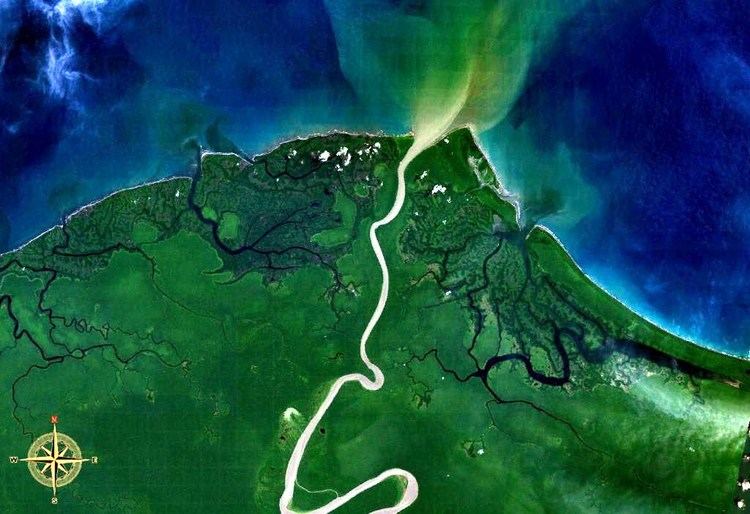
Map of Sungai Mamberamo, Indonesia
The source of the river is formed from the confluences of its upper tributaries, the Tariku and Taritatu Rivers. From there it flows northwards in a great valley through the Van Rees Range (Pegunungan Van Rees), to reach the lowland marshes of its broad river delta. The Mamberamo discharges into the Pacific Ocean at the northern point of Point D'Urville (Tanjung D'Urville).
The river's huge valley is home to various uncontacted peoples and incredible biodiversity. In the 1990s, the Indonesian Government had plans to construct a large hydroelectric dam on the Mamberamo that would have submerged much of the area. This plan was shelved after the Indonesian financial crisis from 1998–1999, but there are concerns by environmental groups that it could be resurrected sometime in the future. At present, the Mamberamo remains the second largest river in the world to be completely unfragmented by dams in its catchment, behind only the relatively nearby Fly.
The Mamberamo area also broadly refers to several nearby mountain ranges, including the Van Rees and Foja Mountains (also known as Foya), which were the subject of a recent rapid biological assessment conducted by Conservation International, the Indonesian Institute of Sciences, and Cenderawasih University. The scientific team discovered the first new bird species from New Guinea in 60 years, and a wealth of other new plants and animals. The Foya Mountains appear to be a globally outstanding repository of biodiversity.
History
In 1545, the Spanish navigator Iñigo Ortiz de Retes sailed along the northern coast of the island as far as the mouth of this river that he charted as San Agustín. At this spot, on 20 June 1545, he claimed the territory for the Spanish Crown, and in the process bestowing the name to the island (Nueva Guinea) by which it is known today.
The first European to enter the mouth of the Mamberamo was Dutchman Dr D. F. van Braam Morris in 1883. The resident from the northern Moluccas (Ternate) rowed up the river to ascertain that it was navigable by steamer. The following year in 1884 Van Braam Morris returned in the steamship Havik and travelled 60 mi (97 km) (as the crow flies) along its course.
Mamberamo Bridge
The Mamberamo Bridge was the second longest cable stayed span in Indonesia after Kutai Kartanegara Bridge with 235 meters and 270 meters respectively until the latter bridge collapsed in November 2011.