
Population 1,907 (2006 census) Local time Sunday 11:18 PM | Postcode(s) 2536 Postal code 2536 Federal division Division of Eden-Monaro | |
 | ||
Weather 22°C, Wind N at 6 km/h, 95% Humidity | ||
Malua Bay (postcode: 2536) is a locality in the South Coast region of the state of New South Wales, Australia. It is situated in the Eurobodalla Shire. At the 2006 census, Malua Bay had a population of 1,907 people.
Contents
Map of Malua Bay NSW 2536, Australia
Malua Bay town centre is located astride George Bass Drive, which is approximately 13 kilometres drive from the town of Batemans Bay. The town boundaries extend to Dunns Creek Road in the West, Ridge Road to the North, and almost to Burri Road in the South, where it abuts the town of Rosedale. Malua Bay is approximately 280 km (170 mi) South of Sydney, and 160 km (99 mi) East of Canberra via the Kings Highway.
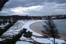
Malua Bay has a range of beaches and bays on its border with the Tasman Sea, including; Malua Bay Beach, Mosquito Bay, Garden Bay, and McKenzies Beach. Recreational fishing is popular from the rocks at many of these beaches. Surfing is the predominant activity at McKenzies Beach and there is a public-access boat launching ramp at Mosquito Bay.