
Local time Sunday 7:40 AM | Time zone EET (UTC+2) | |
 | ||
Weather 14°C, Wind SW at 19 km/h, 87% Humidity | ||
Maleme (Greek: Μάλεμε) is a small village and military airport 16 km (9.9 mi) to the west of Chania, in north western Crete, Greece. It is located in Platanias municipality, in Chania regional unit.
Contents
Map of Maleme 730 14, Greece
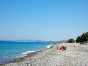
Maleme has many large hotels and several pleasant apartments close to the beach as well as bars and cafés. It is known for its crystal clear pebble shores and the magnificent views of "Thodorou" island and Kolymbari. Among other places in Maleme, visitors can discover the German Cemetery with its magnificent view, the historical Minoan tomb as well as a traditional ceramics workshop where visitors can learn the history of pottery in Crete and Chania and see how ceramics are made. Other interesting hot-spots of Maleme include a variety of shops with local products (wine, honey, cheese). Food lovers can easily satisfy any taste as you can find anything in Maleme, from wood-burning oven pizza to gyros and fresh seafood.
There is a large and newly constructed supermarket at the center of Maleme where visitors and locals can find anything they wish and a bus stop across the street leading to Chania city center and other areas.
Bronze Age
A Late Minoan tholos tomb has been discovered in the vicinity of Maleme.
World War II
Maleme is best known as a landing site for German paratroopers invading Crete in 1941, at the start of the Battle of Crete (Operation Mercury) during World War II. The paratroopers captured the airstrip, which was located just outside the town. Once captured, this airstrip allowed the Germans to airlift in the reinforcements needed to capture the rest of the island. Many of the paratroopers lost their lives in the attack and are buried in the German war cemetery (35.522395°N 23.8311892°E / 35.522395; 23.8311892) located on a hill above Maleme.
There is a Royal Air Force (RAF) memorial to the airmen of 30 and 33 Squadrons who died during the battle. The memorial is located (35.525363°N 23.828619°E / 35.525363; 23.828619) behind the roadside hedge between Maleme and Tavronitis overlooking the (35.526625°N 23.825604°E / 35.526625; 23.825604) Iron Bridge across the Tavronitis River and the end of Maleme aerodrome.