
Population 2,925 (2010) | Highest elevation 239 m (784 ft) Barangay Elevation 239 m | |
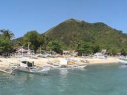 | ||
Malangabang (variously Malangaban) is an island and barangay in northeastern Iloilo, Philippines. It is part of the municipality of Concepcion. According to the 2010 census, it has a population of 2,925. Fishing is the main source of income for the island's residents.
Contents
Map of Malangabang, Concepcion, Philippines
Location and geography
Malangabang Island is east of Panay Island in the Visayan Sea. Part of the Concepcion Islands, it is a wooded island and is 239 metres (784 ft) at its highest point. Malangabang is 3.2 kilometres (2 mi) southeast of Pan de Azucar. Malangabang completely surrounds the small Chico Island. Malangabang's sole barangay is also named Malangabang.
Typhoon Haiyan
In 2013, Typhoon Haiyan (locally known as Yolanda) struck Malangabang with 20 feet (6.1 m) waves, and many residents lost their boats to the storm. All told, the storm destroyed at least 470 boats and 370 houses. After the storm passed, several relief organizations went to Malangabang to deliver aid and offer assistance, including Multicultural Response, the Philippine Medical Association's Doctors on Boat project, and the Korea-based 601 Habitat.