
Official name Jayakwadi Stage-II Dam Opening date 1987 Type of dam Earthfill Height 31 m Surface area 78.13 km² Turbine 3 | Construction cost Rs 54,300 Lakhs Catchment area 3,840 km² | |
 | ||
Similar Upper Wardha Dam, Jayakwadi Dam, Dowleswaram Barrage, Godavari Arch Bridge, Old Godavari Bridge | ||
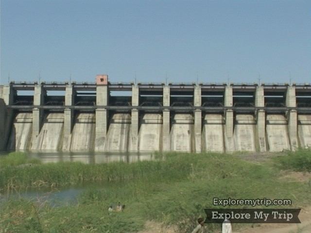
Majalgaon Dam is an earthfill dam on the Sindphana River near Majalgaon, Beed district in the state of Maharashtra, India.
Contents
- Map of Majalgaon Dam Kedar Sangvi Maharashtra 431131
- History
- Land acquisition and Rehabilitation
- Purpose
- Specifications
- Yield and Utilization
- Dam and reservoir
- Outlet details
- Crops in irrigation area
- Power generation
- Dimensions
- Spillway
- References
Map of Majalgaon Dam, Kedar Sangvi, Maharashtra 431131
History
Majalgaon dam and Majalgaon Right Bank Canal are components of the Jaikwadi Project Stage II. A dam has been constructed across the Sindhaphana river, which is a major tributary of the Godawari river, also known as Dakshin Ganga. The project was approved by the government of Maharashtra in 1976 for an estimated cost of Rs 5433 lakhs.
Majalgon Dam is to be built from earth berms on either side of a gated concrete spillway. The spillway will be approximately 2 kilometers upstream from the town of Majalgaon. The dam will have three hydroelectric generators, each capable of generating 750 kilowatts. In addition, a canal 165 kilometers long was constructed to irrigate 93885 hectares (ICA) of land in Beed, Parbhani & Nanded districts.
Land acquisition and Rehabilitation
34 Villages were affected by construction of the dam. Out of these 34, 18 are submerged and two are partly under water. The total area of land covered by water is 7813 ha. No forest land was flooded, and affected villages are relocated in 26 new gawthans.
The height of the dam from its foundation is 31.19 m (102.3 ft) while the length is 6,488 m (21,286 ft). The volume content of dam is 5.759 million cubic meters and gross water storage capacity behind the dam is 0.453640 km3 (0.108834 cu mi).
Purpose
Specifications
Yield and Utilization
Dam and reservoir
Outlet details
type Conduct Conduct F.S Discharge 83.8 Cumecs 20 Cumeecs
Crops in irrigation area
District wise Benefited area (I.C.A. in ha)
Power generation
Dimensions
Height
QUANTITY: