
Population 1,056 (2006 census) Postcode(s) 5573 Elevation 160 m Local time Sunday 1:46 AM | Established 1872 State electorate(s) Goyder Postal code 5573 | |
 | ||
Location 168 km (104 mi) west of Adelaide164 km (102 mi) south of Port Pirie50 km (31 mi) south of Kadina46 km (29 mi) north of Minlaton Weather 19°C, Wind E at 11 km/h, 45% Humidity | ||
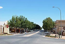
Maitland is a town in South Australia located 168 km west of Adelaide by road, 164 km south of Port Pirie and 46 km north of Minlaton known as the "heart of Yorke Peninsula" due to being near the centre of the region. At the 2006 census, Maitland had a population of 1,056.
Map of Maitland SA 5573, Australia
Maitland is within a short driving distance of coastal towns on either side, with Port Victoria to the west and Ardrossan to the east, each within 25 km.
The town was named in 1872 after Lady Jean Maitland, the wife of the First Lord of Kilkerran, a family connection of the governor of South Australia at this time, Sir James Fergusson; the local aborigines calling it "madu waltu", meaning white flint.
Maitland has a grain receiving depot operated by AWB Limited, serviced only by road. Maitland is also the home base of the Narungga Aboriginal Progress Association.
Maitland's urban design is patterned after Adelaide's central business district: a neat grid of streets surrounded on all four sides by parkland.