
- elevation 450 m (1,476 ft) Length 230 km Discharge 85 m³/s Cities Arnprior | - elevation 70 m (230 ft) Basin area 8,470 km² | |
 | ||
- location Arnprior, Renfrew County | ||
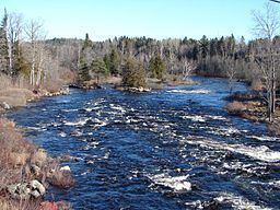
The Madawaska River is a river in the Saint Lawrence River drainage basin in Ontario, Canada. The river is 230 km (143 mi) long and drains an area of 8,470 km2 (3,270 sq mi). Its name comes from an Algonquian band of the region known as "Matouweskarini", meaning "people of the shallows".
Contents
Course
For a map showing the river course, see this reference.
The Madawaska River originates at Source Lake in geographic Canisbay Township in the Unorganized South Part of Nipissing District, in the highlands of southern Algonquin Park. It flows east, dropping 380 m (1,247 ft) before emptying into the Ottawa River at Arnprior.
History
In the late 19th century, the river was used to transport lumber from the forested areas surrounding the river. Beginning in the 1960s, the river was used to generate hydroelectric power. Undammed sections of the river are also used for canoeing, kayaking and recreational fishing.
Tributaries
Lakes and reservoirs
The lower portion of the Madawaska River supports several large lakes, including:
Fauna
Most common species of game fish found in this river include: Walleye (Yellow Pickerel), Northern Pike, Muskellunge, Smallmouth Bass, and Large Mouth Bass.
Provincial Parks
Two sections of the river are designated and protected as provincial waterway parks:
Both parks are administered by Ontario Parks but are non-operating, meaning there are no visitor facilities or services available. Both are ideal for whitewater canoeing.