
- elevation 4,845 ft (1,477 m) Discharge 44.54 m³/s Basin area 1,287 km² | - elevation 0 ft (0 m) Length 182 km Basin area 1,287 km² | |
 | ||
- right Barry Creek, Pilot Creek, Bug Creek, Graham Creek, Boulder Creek, Maple Creek, Canõn Creek, North Fork Mad River, Lindsay Creek, Mill Creek - average 1,573 cu ft/s (44.5 m/s) | ||
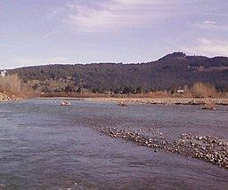
The Mad River is a river in upper Northern California. It flows for 113 miles (182 km) in a roughly northwest direction through Trinity County and then Humboldt County, draining a 497-square-mile (1,290 km2) watershed into the Pacific Ocean north of the college town of Arcata near Arcata-Eureka Airport in McKinleyville. The river's headwaters are in the Coast Range near South Kelsey Ridge.
Contents
- Map of Mad River California USA
- HistoryEdit
- Watershed and river modificationsEdit
- Land useEdit
- EcologyEdit
- References
Map of Mad River, California, USA
HistoryEdit
Before Euro-American settlers arrived in the mid-1800s, the native peoples occupying the lower Mad River watershed were the Wiyot (from approximately Blue Lake to its mouth, plus the greater Humboldt Bay region) who spoke a dialect affiliated with the Algonquian language family, with upriver reaches controlled by three different groups whose languages are related to the Athabascan family, the Whilkut, Nongatl and Lassik (Baumhoff 1958). Today, among these distinct groups, only the Wiyot-affiliated Blue Lake Rancheria is a federally recognized tribe and holds lands in trust for its citizens. The Whilkut, Nongatl and Lassik were essentially annihilated during the Bald Hills War in the 1860s. The river was named in December, 1849 in memory of an incident when Dr. Josiah Gregg lost his temper when his exploration party did not wait for him at the river mouth.
Watershed and river modificationsEdit
The Mad River drains approximately 497 square miles (1,290 km2) of the Coast Range Geomorphic Province and empties into the Pacific Ocean north of Humboldt Bay in Humboldt County, California. The basin is about 100 miles (160 km) in length and averages six miles (10 km) wide. Elevations range from sea level at the mouth to 3,000 feet (910 m) along the western ridge to 6,000 feet (1,800 m) in the headwaters. Principal tributaries to the Mad River include South Fork Mad River, North Fork Mad River, Barry Creek, Pilot Creek, Deer Creek, Bug Creek, Graham Creek, Grace Flat, Blue Slide Creek, Boulder Creek, Maple Creek, Canõn Creek, Lindsey Creek, and Mill (Hall) Creek.
The river provides groundwater recharge for agricultural water supplies and is free-flowing for 85 percent of its length. Matthews Dam, about one third of the way down the river from its source, forms Ruth Reservoir. The dam is owned by Humboldt Bay Municipal Water District, which provides water from Ranney collectors near Essex for municipal and industrial use in Eureka, Arcata, Blue Lake and numerous unincorporated communities in the Humboldt Bay area. The reservoir can hold 48,000 acre feet (59,000,000 m3) of water; and releases power a two megawatt hydro-electric plant generating 5 million kwh during an average water year.
The greatest problem of the Mad River drainage basin, as for many rivers in this area of the state, is erosion causing excessive sediment buildup in the river and its tributaries. The main causes of the erosion are excessive road building and logging, especially historical logging practices like clear-cutting. In addition, the removal of riparian vegetation (primarily due to conversion of natural lands to ranching purposes) increases erosion and urbanization causes decreased water quality. In 1992, the Environmental Protection Agency added the Mad River to California’s Clean Water Act Section 303(d) impaired water list due to elevated sedimentation/siltation and turbidity.
Land useEdit
The upper half of the river is inside the Six Rivers National Forest, but the vast majority of the river flows through private land, even in the national forest. About 64 percent of the land is used for timber production. Green Diamond is by far the largest landowner in the watershed, with about 42 percent of all land. The next largest landowners are R. Emmerson and Humboldt Redwood Company (formerly the Pacific Lumber Company), with 3 and 2 percent respectively. There are quite a few ranchers and lumber companies that own smaller, but still sizable, parcels. Private residences, open space and parks make up most of the rest.
EcologyEdit
The river provides recreation and wildlife habitat for preservation of rare and endangered species including warm and cold freshwater habitat for fish migration and spawning. Flora of the area includes the Mad River fleabane (Erigeron maniopotamicus), a wildflower which was named for the river.
Chinook salmon (Oncorhynchus tshawytscha), coho salmon (O. kisutch),steelhead and resident coastal rainbow trout (O. mykiss irideus), coastal cutthroat trout (O. clarki clarki), and the occasional sockeye salmon (O. nerka) and chum salmon (O. keta). The Mad River watershed also contains several non-salmonid fish species. Native resident fish include the Pacific lamprey (Lampetra tridentata), prickly sculpin (Cottus asper), coast range sculpin (C. aleuticus), Sacramento sucker (Catostomas occidentalis), Humboldt sucker (Catostomas occidentalis humboldtianus), three-spine stickleback (Gasterosteous aculeatus), and estuarine species such as longfin smelt (Spirinchus thaleichthy), starry flounder (Platichthys stellatus), and eulachon (Thaleichthys pacificus). California roach (Lavinia ssymmetricus), brown bullhead (Ictalurus nebulosus), largemouth bass (Micropterus salmoides), and green sunfish (Lepomis cyanellus) represent non-native fish species introduced into the watershed.
Mad River estuary is recognized for protection by the California Bays and Estuaries Policy. The Mad River watershed was described as at carrying capacity with 22 colonies of North American beaver (Castor canadensis) in 1954, from the river mouth to well upstream. These beaver were re-introduced into the North Fork Mad River in 1946, or possibly were migrants from the Little River (Humboldt County). North American river otter (Lontra canadensis) were also numerous.