
Opening date 1968 Height 55 m Province New Brunswick Construction began 1965 | Status Operational Type of dam Embankment dam Opened 1968 | |
 | ||
Official name Mactaquac Generating Station Similar Government House - Fredericton, Odell Park, Fredericton Region Museum, Officers' Square, Science East | ||
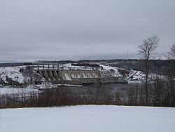
The Mactaquac Dam is an embankment dam used to generate hydroelectricity in Mactaquac, New Brunswick. It dams the waters of the Saint John River and is operated by NB Power with a capacity to generate 670 megawatts of electricity from 6 turbines; this represents 20 percent of New Brunswick's power demand.
Contents
- Map of Mactaquac Dam Kingsclear NB Canada
- LocationEdit
- ConstructionEdit
- LifespanEdit
- Flooding of the Mactaquac HeadpondEdit
- Inspiration for arts and cultureEdit
- References
Map of Mactaquac Dam, Kingsclear, NB, Canada
LocationEdit
Formally called the Mactaquac Generating Station, the dam and power house are located approximately 19 km (12 mi) upstream from the city of Fredericton. The dam is an embankment dam consisting of a rock-fill structure sealed by clay. It combines with two concrete spill-ways to form an arch across a narrow section of the river between the communities of Kingsclear on the west bank, and Keswick Ridge on the east bank.
ConstructionEdit
Rising 40 metres in height above the river level, the reservoir (referred to locally as the "head pond") covers 87 square kilometres and extends 96 kilometres upstream, near Woodstock. The dam and powerhouse are a "run of the river" design, meaning that the reservoir has no additional holding capacity in the event of unusually high water flows, such as during the spring freshet.
Kingsclear, NB is also the site of an Atlantic Salmon fish hatchery, located immediately downstream from the dam. The Mactaquac Dam also has a fishway to catch salmon and transport them upriver.
The dam also serves as a locally important public road bridge across the Saint John River, linking provincial highways 102 and 105 on the south and north sides of the river.
LifespanEdit
The concrete portions of the dam (namely the spill-ways) are currently experiencing a problem of expanding concrete. When built, locally quarried greywacke was used as the aggregate and is responsible for an alkali-aggregate reaction expansion. The dam is being monitored and extra maintenance work is being performed, although the original 100-year lifespan of the spillway has been reduced by almost 40 years.
On October 1, 2014, NB Power officials presented 3 options for the facility to the provincial utility regulator, the New Brunswick Energy and Utilities Board. A decision will have to be made by 2030 to either restore or decommission as follows:
All 3 options have a minimum cost of $2 billion (as of 2014), however, the first option also has an additional cost of $1–3 billion and the third option has not had a complete cost estimate provided.
The reduced lifespan of the spillway and dam was first brought to the attention of the provincial government in 2000 when projections by NB Power at that time had placed the dam's end-of-life at 2028, instead of the original 100-year lifespan of 2068. NB Power officials would not say at that time how much it would cost, nor when those costs would show up on the utility's accounts.
Flooding of the Mactaquac HeadpondEdit
Electrical generation began in 1968 after the reservoir, Mactaquac Lake, had completely filled. The flooding of the valley resulted in the displacement of several thousand residents and land owners in areas such as Bear Island and other small communities, as well as the abandonment of a Canadian National Railway line and numerous local roads and small rural communities. A historic waterfall called the Pokiok Falls was also submerged as the reservoir filled.
Some new infrastructure was also built as part of the planned flooding of the Saint John River valley. The provincial government built Highway 2 (the Trans Canada Highway) along the southwestern shoreline of the flooded valley. Since 2002, this road has been bypassed and is now designated Highway 102. The Hawkshaw Bridge, a cable-stayed suspension bridge, was constructed across the valley from Hawkshaw to Southampton. At the time of construction in 1967, the bridge was high above the valley floor and the original river level. The planned town of Nackawic, New Brunswick and the nearby Ste-Anne-de-Nackawic pulp and paper mill were also built to accommodate the new reservoir and the new electrical power opportunities. Closer to the dam, the Mactaquac Provincial Park, including a marina and beach was also built.
Following the success of preserving historic buildings at Upper Canada Village when the upper St. Lawrence River valley was flooded by the Long Sault Dam, the government of New Brunswick created the King's Landing Historical Settlement to save several buildings which would otherwise have been flooded by the Mactaquac Headpond.
Inspiration for arts and cultureEdit
The building of the dam was the inspiration for Riel Nason’s 2011 novel The Town That Drowned, published by Goose Lane Editions. The fictional book, winner of the 2012 Commonwealth Book Prize, is set in the 1960s near Pokiok Falls, where the characters learn their homes will soon be swallowed by the rising water.