
Existed: c. 1959 – present Length 27.37 km | Constructed 1959 | |
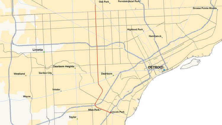 | ||
M-39 is a 16 miles (26 km) long state trunkline highway in Metro Detroit area of the US state of Michigan that runs from Lincoln Park, on the south end, to Southfield on the north. The official southern terminus of M-39 is at the corner of Southfield Road and Lafayette Boulevard in Lincoln Park, one block southeast of the junction of Interstate 75 (I-75, Fisher Freeway) and two blocks northwest of M-85 (Fort Street). From there the highway heads northward. The first 2.3 miles (3.7 km) of the highway follows Southfield Road, a divided highway in the Downriver area. It then transitions into the Southfield Freeway, which is a 13.7 miles (22.0 km) long freeway that runs from Allen Park north through Dearborn, and then the west side of Detroit, to Southfield. The northern terminus is at M-10 (Lodge Freeway) in Southfield.
Contents
- Map of Southfield Pl Virginia Beach VA 23452 USA
- Route description
- Previous designations
- Current designation
- References
Map of Southfield Pl, Virginia Beach, VA 23452, USA
The current M-39 is the third highway to bear the designation. The first dated back to the origins of the state highway system in 1919 and ran between Grand Rapids and Lansing. This highway was replaced in segments through the 1920s and 1930s by realignments or extensions of other highways in the area. The second was part of Schaefer Highway in the Detroit area from 1939 until the end of the 1950s. The current highway was commissioned when the M-39 designation was moved to Southfield Road from Schaefer Highway. During the 1960s, it was converted into a freeway in stages. Afterwards, it was extended to end at M-85 (Fort Street) before a change in the 1980s gave the trunkline its present termini.
Route description
M-39 begins at Lafayette Boulevard a block east of its junction with I-75 in Lincoln Park. From there the road is a six-lane boulevard through residential areas as it runs west-northwesterly to pass under I-75. In Allen Park, the highway continues through residential and commercial areas. Southfield Road crosses lines of the Norfolk Southern Railway and Conrail Shared Assets Operations near the location where the highway turns to the northeast and transitions into a six-lane limited-access freeway. Immediately after this transition, the Southfield Freeway, as M-39 is now called, has an interchange with I-94. There is a second, adjacent interchange that connects to Van Born Road, and the freeway winds its way northeasterly through Dearborn. The freeway is bordered by service drives that carry one-way traffic and bear the Southfield Road name on either side. M-39 meets Outer Drive near the campus of the University of Michigan–Dearborn. The adjoining properties are residential to the west and commercial to the east. Near Greenfield Village, the freeway curves to the northwest around the Ford Proving Grounds before turning to the north, a direction it will maintain until the end of its run. The freeway crosses the River Rouge and meets US Highway 12 (Michigan Avenue) next to the Fairlane Town Center and Ford Motor Company's world headquarters in Dearborn.
North of the interchange for M-153, (Ford Road), M-39 crosses into Detroit. From there the road continues through the densely populated areas of the west side of the city. Next to the Chicago Road overpass, the freeway runs under a CSX Transportation rail line. The trunkline continues traveling to the north through a series of interchanges. The first is a partial interchange for Plymouth Road; northbound traffic exiting here is directed to use the service drive northbound to access Schoolcraft Road, and traffic can enter M-39 southbound. Next is the stack interchange with I-96 (Jeffries Freeway) with access to both the local and express lanes of that freeway. The last of the series is another partial interchange with Schoolcraft Road. As a counterpart to the Plymouth Road interchange, this one provides access from southbound M-39 to the cross street with a signed connection along the southbound service drive to Plymouth Road and an entry point for northbound traffic. Continuing north, M-39 comes to an interchange with M-5 (Grand River Avenue) which also connects to Fenkell Avenue, the 5 Mile Road equivalent on Detroit's mile road system.
There are three more interchanges along M-39 in Detroit as the freeway continues through the residential upper west side. Near the Wayne Community College District, the freeway meets McNichols Road (6 Mile). There is another interchange approximately one mile (1.6 km) north at 7 Mile Road as well. The road then crosses the border between Wayne and Oakland counties to enter Southfield at the interchange with M-102 (8 Mile Road). The Southfield Freeway, and M-39, terminates at an interchange with M-10 (John C. Lodge Freeway) near 9 Mile Road. Southfield Road continues northward from the end of the freeway under local maintenance.
M-39 is maintained by the Michigan Department of Transportation (MDOT) like other state highways in Michigan. As a part of these maintenance responsibilities, the department tracks the volume of traffic that uses the roadways under its jurisdiction. These volumes are expressed using a metric called annual average daily traffic, which is a statistical calculation of the average daily number of vehicles on a segment of roadway. MDOT's surveys in 2010 showed that the highest traffic levels along M-39 were the 159,400 vehicles daily between Schoolcraft Road and Grand River Avenue in Detroit; the lowest counts were the 20,400 vehicles per day between the I-94 and Van Born Road interchanges. All of M-39, and Southfield Road on either end that is not under state maintenance, has been listed on the National Highway System, a network of roads important to the country's economy, defense, and mobility.
Previous designations
Two previous highways bore the M-39 designation. When the state highway system was first signed in 1919, the number was assigned to a highway that ran between Grand Rapids and Lansing. The westernmost end in Kent County near Alto was replaced by a realigned M-16. Within the next few years, the western end was scaled back further to the Woodbury area when M-50 was extended, with the remainder replaced by an extended M-43 around 1938.
The next trunkline to be designated M-39 was Schaefer Highway in 1939, running north–south from US 25 (Dix Avenue) in Melvindale to US 16 (Grand River Avenue) in western Detroit. Since M-39 was moved to Southfield Road in the end of the 1950s, Schaefer Highway has been a locally maintained road.
Current designation
M-39 was reassigned to Southfield Road, connecting I-94 with Northwestern Highway in 1958-59. By 1961, the freeway was marked as under construction on maps. The first section opened in December 1961 was 2.7 miles (4.3 km) from Ford Road north to Chicago Road. The remainder of the freeway between I-94 and the Lodge Freeway and 9 Mile Road was opened by the middle of 1964 at a total cost of $40 million. The highway designation was extended southeasterly along Southfield Road to the new I-75 freeway and a terminus at M-85 (Fort Street) in 1966. In 1987, the M-39 designation was truncated slightly so that the trunkline no longer officially connects to M-85.