
Length 187.7 km | ||
 | ||
Existed: c. July 1, 1919 – present Counties Manistee County, Michigan, Benzie County, Michigan, Leelanau County, Michigan, Grand Traverse County, Michigan | ||
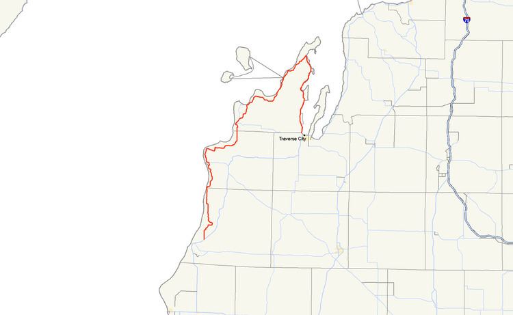
M-22 is a state trunkline highway in the US state of Michigan. It is 116.651 miles (187.732 km) long and follows the Lake Michigan shoreline of the Leelanau Peninsula, making up a portion of the Lake Michigan Circle Tour. It also passes through the Sleeping Bear Dunes National Lakeshore. The highway is U-shaped as it rounds the peninsula running through tourist areas in Leland and Suttons Bay in addition to the national park.
Contents
Map of M-22, Michigan, USA
M-22 is an original trunkline designation dating back to the 1919 designation of the system. Reroutings have moved the highway closer to the water between Suttons Bay and Traverse City. A section of the highway used temporarily even was used for another highway, M-109. The highway was also named what is now called a Pure Michigan Byway. The route marker is used in marketing by a local business as a symbol of the region.
Route description
The southern terminus is 3 miles (4.8 km) northeast of Manistee and the northern terminus is in Traverse City. In between the trunkline loops north along Lake Michigan to Northport before turning south along the West Arm of Grand Traverse Bay. The road itself comprises numerous turns and hills, making it a very popular drive for tourists visiting the area from areas such as Chicago and Detroit, especially during autumn. The road runs north to the village of Onekama running east and north of Portage Lake before returning north to Arcadia. M-22 turns northeasterly to curve around the north shore of Crystal Lake after passing through Elberta and Frankfort. South of the Platte River, the highway crosses into the Sleeping Bear Dunes National Lakeshore. East of Platte Lake, M-22 turns northward again toward Empire, headquarters of the national park. M-22 takes the inland route between Little and Big Glen lakes, losing the Lake Michigan Circle Tour designation to M-109 until the two meet again in Glen Arbor. The roadway follows the shoreline of Pyramid Point and passes east out of the national park before turning north to Leland.
Leland is home to Fishtown, and the ferries to the Manitou Islands off the coast of the Leelanau Peninsula. Continuing northward, M-22 reaches its northernmost extent in Northport before turning south. It passes through the reservation of the Grand Traverse Band of Chippewa and Ottawa Indians in Peshawbestown, home to one of the tribe's two casinos. Further south is the community of Suttons Bay located on the small bay of the same name. From here south, the highway runs just off the shore of the Grand Traverse Bay south to Greilickville. Just south of Greilickville, M-22 enters a section of the city of Traverse City that's located in Leelanau County, Michigan formed by an acquisition of a neighborhood of Greilickville. Here is the eastern junction between M-22 and M-72. The two highways run concurrently along Grandview Parkway to Division Street. There they meet US 31/M-37 and M-22 ends. A portion of this road has been designated a what is now called a Pure Michigan Scenic Byway by the state of Michigan.
History
M-22 is an original trunkline, dating to the July 1, 1919 designation of the system. In 1929, the highway was rerouted along the west side of Little Glen Lake, using the modern M-109 around the lake. M-22 would be rerouted back around to the present routing the next year, and M-109 was designated on the west side of the lake in its place.
Until 1936, M-22's route was on Cherry Bend and Center roads in Leelanau County to Suttons Bay. At that time, M-22 was relocated along the west arm of Grand Traverse Bay onto Center Road up to Crain Hill Road In 1949, M-22 was relocated the rest of the way to Suttons Bay, and the former M-22 on Cherry Bend and Center roads became County Road 633. and in 1945, the last gravel stretch of M-22 from Leland to Northport was paved.
In Traverse City, M-22 originally started at Front and Union streets going west on Front to Elmwood, turning north onto Elmwood, then west on Bay Street to Greilickville. It was relocated onto the newly built Grand View Parkway in 1952, from Greilickville to Division Street (relocated US 31).