
Country United States County Leelanau Area code(s) 231 Elevation 185 m Population 526 (2013) | State Michigan Time zone Eastern (EST) (UTC-5) FIPS code 26-58740 Zip code 49670 Local time Sunday 3:46 PM | |
 | ||
Weather 6°C, Wind SW at 11 km/h, 60% Humidity | ||
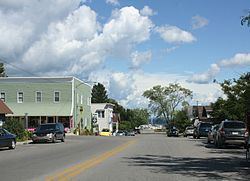
Northport is a village in Leelanau Township, Leelanau County in the U.S. state of Michigan. The population was 526 according to the 2010 U.S. census. When Leelanau County was formed in 1863, Northport served as the first county seat from 1863 to 1883.
Contents
- Map of Northport MI 49670 USA
- History
- Geography
- Notable residents
- Local attractions
- Places of interest
- Education
- 2010 census
- 2000 census
- References
Map of Northport, MI 49670, USA
History
In 1848 Michigan suffered from a smallpox epidemic that affected the entire community of people. Chief Peter Waukazoo and Reverend George Smith moved the community as well as the Holland-area Ottawa Mission up to the Leelanau Peninsula on boats or canoes. When the settlers had reached their destination they called it Waukazooville. Another man named Deacon Joseph Dame had come to Waukazooville in 1854, he had decided to change the name to Northport at this time.
Northport was the largest town in Leelanau County for quite a while in the 1800s and 1900s. Several general stores were built in the town in 1859 that sold items such as cloth, thread, needles, foods, axes, and more. There was no doctor in town at this time so Reverend Smith was called on to deliver babies, help the ill, & numerous other things.
1850s were a very hard time for the people of Northport, as they sat back and watched as the Civil War unfolded. However, by 1861 they could not just wait anymore, only a few men enlisted and were soon shipped out. As the year went on, they began recruiting more men from Northport who ended up joining the fight. Hard times came and went for the men in the war and the families back in Northport. Finally April 9, 1865 came around and the soldiers had gone back to Northport due to the end of the war.
The planting of crops, as well as growing, was a hard time for the people of Northport in the late 1800s. Having sanitary food was a necessity that sometimes was lacking in Northport. Many people that ended up living in Northport came from New York or Canada where the crops & economics were going down the drain.The fishermen, farmers, and other community would gather on the bay and cut chunks of ice for fisheries, hotels, or even private homes.
The Cherry industry that is so prevalent in Northport today had just begun in 1853 on Reverend Smith's farm. Farmers began producing cherries so much within those first few years that cherries were being shipped to nearby cities for their markets. By the 1960s cherry industry took a turn. In 1853 cherries were being harvested by hand or mechanically operated limb shakers, by the 1970s most farmers were using mechanical trunk shakers due to the damage that the tree was undertaking.
Geography
According to the United States Census Bureau, the village has a total area of 1.65 square miles (4.27 km2), all land.
Notable residents
Northport has gained fame for being an area where the rich and famous can live quietly and anonymously. According to the Leelanau Visitors Guide: "Chef Mario Batali lives north of town at Cathead point, and comedian and actor Tim Allen routinely spends summers in Northport. Mark Spitznagel, who manages a multi-billion dollar hedge fund, owns a 150 acre ranch in Northport. He summers in Northport Point, a posh community just outside the village." (Batali's and Spitznagel's Northport home and farm, respectively, both were featured in The New York Times.)
Speedskater and 2010 Olympic silver medalist Jonathan Kuck regularly vacations with his family at their summer home just outside Northport.
The second commander of the American Legion, war hero and businessman Frederic W. Galbraith, maintained a summer home in Northport during the 1910s and early 1920s.
Local attractions
Events
Places
Places of interest
Frank Lloyd Wright designed the Amy Alpaugh House, located in Northport, in 1947.
Education
2010 census
As of the census of 2010, there were 526 people, 251 households, and 147 families residing in the village. The population density was 318.8 inhabitants per square mile (123.1/km2). There were 405 housing units at an average density of 245.5 per square mile (94.8/km2). The racial makeup of the village was 93.2% White, 0.6% African American, 2.5% Native American, 0.2% Asian, 0.4% from other races, and 3.2% from two or more races. Hispanic or Latino of any race were 6.1% of the population.
There were 251 households of which 15.9% had children under the age of 18 living with them, 48.2% were married couples living together, 8.0% had a female householder with no husband present, 2.4% had a male householder with no wife present, and 41.4% were non-families. 37.5% of all households were made up of individuals and 19.9% had someone living alone who was 65 years of age or older. The average household size was 2.10 and the average family size was 2.63.
The median age in the village was 57.5 years. 14.4% of residents were under the age of 18; 6.6% were between the ages of 18 and 24; 13.5% were from 25 to 44; 29.4% were from 45 to 64; and 36.1% were 65 years of age or older. The gender makeup of the village was 46.4% male and 53.6% female.
2000 census
As of the census of 2000, there were 648 people, 272 households, and 174 families residing in the village. The population density was 389.7 per square mile (150.7/km²). There were 391 housing units at an average density of 235.1 per square mile (90.9/km²). The racial makeup of the village was 96.14% White, 0.31% African American, 2.16% Native American, 0.31% Asian, 0.31% from other races, and 0.77% from two or more races. Hispanic or Latino of any race were 3.55% of the population.
There were 272 households out of which 21.7% had children under the age of 18 living with them, 52.2% were married couples living together, 9.2% had a female householder with no husband present, and 35.7% were non-families. 32.4% of all households were made up of individuals and 15.1% had someone living alone who was 65 years of age or older. The average household size was 2.18 and the average family size was 2.69.
In the village, the population was spread out with 18.4% under the age of 18, 4.2% from 18 to 24, 17.4% from 25 to 44, 28.7% from 45 to 64, and 31.3% who were 65 years of age or older. The median age was 50 years. For every 100 females there were 86.7 males. For every 100 females age 18 and over, there were 83.0 males.
The median income for a household in the village was $40,368, and the median income for a family was $48,750. Males had a median income of $31,042 versus $26,786 for females. The per capita income for the village was $23,786. Roughly 6.7% of families and 9.1% of the population were below the poverty line, including 15.0% of those under age 18 and 3.9% of those age 65 or over.