
Length 5 km | Source Gap | |
 | ||
Main source Arzler wind-gap above Innsbruck1,700 m (5,600 ft) | ||
The Mühlauer Bach also called Worm Creek originates on a height of 1.700 m above Sea Level. It runs via the Arzler wind-gap in southern direction through Mühlau to the Inn River. With exception of the Inn River the creek is the richest flowing waters of the city, has a length of app. 5 km. and lies in full on Innsbruck city area.
Contents
Usage
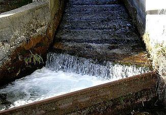
The upper course until Schiller settlement has Grade A quality. There is also the main water reservoir of the entire city. In the near future a part of the water is used for supplying Vill with water by installing a new line. The Creek is also important for industrial purposes because a power plant in Mühlau provides the nearby commercial district with electricity. In the lower course the quality remains constantly at B even though the service water. Small fish population can be found in the broad sections.
Myth
The End of the wind-gap at the Arzler ravine is called „Devil’s pulpit“. Rumour has it that a wyvern was defeated here and its blood turned into water.